
Hide
Kirk Hammerton
Hide
Maintainers
Please check here for information on outstanding issues on the GENUKI system and recent changes made.
hide
Hide
hide
Hide
Hide
The Ancient Parish of KIRK HAMMERTON
[Transcribed information mainly from the early 1820s]
"KIRK HAMMERTON, a parish-town, in the upper-division of Claro; (the seat of William Thompson, Esq.) 6 miles NE. of Wetherby, 8 from Boroughbridge and Knaresborough, 10 from York. Pop. 409. The Church, peculiar is a vicarage, dedicated to St. John the Baptist (see Churches for photograph), in the deanry of Boroughbridge, diocese of Chester, value, p.r. !£134. 10s. In consequence of a reduction, by loss of Land, the value is only £65. Patron, the Rev. William Metcalfe, the present incumbent.""SKIP BRIDGE, an Inn, in the township of Wilstrop, and parish of Kirk Hammerton; 8½ miles SE. of Boroughbridge and York."
[Description(s) edited from various 19th century sources by Colin Hinson © 2013]
Hide
- Here are photographs of Churches etc. in the parish:
- St John the Baptist's Church, Kirk Hammerton (view 1).
- Internal view looking down the nave
- Internal view showing the rood screen and ceiling detail
- St. John the Baptist's Church, Kirk Hammerton (view 2).
- The MethodistChurch, Kirk Hammerton.
- St John the Baptist's Church, Kirk Hammerton (view 1).
- Transcript of the entry for Kirk Hammerton in the "Collections relative to Churches and Chapels".
- The whereabouts and dates of the Registers etc. for the Parish of Kirk Hammerton.
- The List of Vicars in St. John's Church, Kirk Hammerton.
- Transcript of the entry of "professions and trades" in the Baines's Directory and Gazetteer, Vol I, West Riding.
- There is further information about this parish from the National Gazetteer 1868, Yorkshire extracts.
- There is further information about this parish from the Lewis's Topographical Dictionary of England, Yorkshire extracts.
- Ask for a calculation of the distance from Kirk Hammerton to another place.
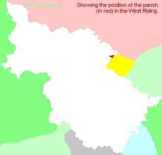
- For a detailed map of this parish see this parish boundaries map.
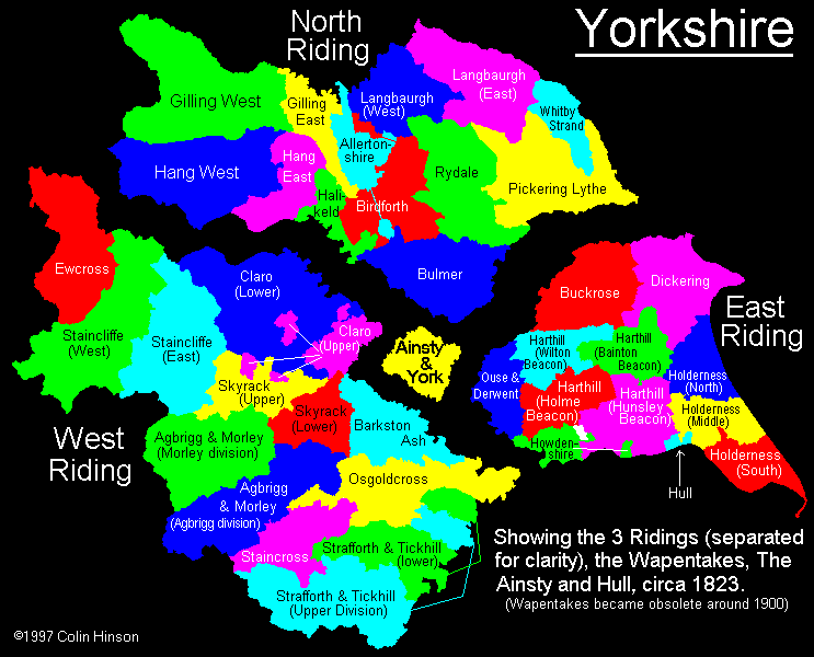
- For a more detailed map of the parishes in the riding please see the Yorkshire parish maps page.
- For a more detailed map of the county please see the Yorkshire map page.
- Here is a map showing the wapentakes for the county.
You can see maps centred on OS grid reference SE465556 (Lat/Lon: 53.994354, -1.292214), Kirk Hammerton which are provided by:
- OpenStreetMap
- Google Maps
- StreetMap (Current Ordnance Survey maps)
- Bing (was Multimap)
- Old Maps Online
- National Library of Scotland (Old Ordnance Survey maps)
- Vision of Britain (Click "Historical units & statistics" for administrative areas.)
- English Jurisdictions in 1851 (Unfortunately the LDS have removed the facility to enable us to specify a starting location, you will need to search yourself on their map.)
- Magic (Geographic information) (Click + on map if it doesn't show)
- GeoHack (Links to on-line maps and location specific services.)
- All places within the same township/parish shown on an Openstreetmap map.
- Nearby townships/parishes shown on an Openstreetmap map.
- Nearby places shown on an Openstreetmap map.
- The War Memorial in St. John's Churchyard.
- This parish is covered (or partly covered) by the following Societies:
- A list of those paying the 1379 Subsidy Rolls (Poll Tax) for this parish.