Hide
Methley
hide
Hide
hide
Hide
Hide
The Ancient Parish of METHLEY
[Transcribed information mainly from the early 1820s]
"METHLEY, a parish-town, in Agbrigg-division of Agbrigg and Morley, liberty of Pontefract; 5 miles NW. of Ferrybridge, 6 miles from Wakefield, 6¾ from Leeds and Pontefract. Pop. 1,499. The Church is a rectory, dedicated to St. Oswald, in the deanry of Pontefract, value, £25. 8s. 6½d. Patron, the King, as Duke of Lancaster.Methley is situated on the banks of the Calder, not far distant from Castleford, and in the reign of Henry IV. was the seat of Robert Waterton, master of horse to that King; and afterwards of the famous Sir John Saville. --Camden.
From Domesday, it appears that Osalph and Cnut, the two Saxon proprietors, before the conquest, had been expelled from it, to make way for the great Norman Lord, Ilbert de Lacy. Subsequently the Manor was granted to the Hospital of St. Nicholas, of Pontefract, in the reign of Henry IV. by the master or warden of which house, it was exchanged with Sir John Waterton for certain advowsons. By this exchange, the Watertons became seized of Methley, and probably built the Manor House, which was afterwards completed and uniformly re built by Baron Saville.
The Church of Methley was in existence at the time of Domesday, but has been wholly re built, and in the present fabric is nothing peculiar, except the chantry on the South side of the choir, founded and endowed by Robert Waterton, in 1424, and which contains many monuments of exquisite workmanship. The greatest piece of antiquity about the Church, is a statue of King Oswald, the Patron Saint, over the south door, far more ancient than any part of the present edifice, and probably contemporary with the foundation of the church and parish. The figure is that of an aged man in robes, with crown and sceptre, somewhat decayed, but yet expressive and majestic in decay. A more detailed and interesting account of the monuments, &c. in this Church, is to be found in Whitaker's Loidis and Elmete." The parish and township of Methley are coextensive."
"METHLEY PARK, (the seat of the Earl of Mexborough), in the parish of Methley, 6¾ miles from Wakefield.
This ancient Mansion is situated between Wakefield and Leeds, in a beautiful and verdant Park, well stocked with deer. It was originally built in the reign of James I. but many alterations have subsequently been made, giving the house, in appearance, a modern character. The Savilles are a very ancient family in this county, where they have constantly resided, even prior to the year 1300. John Saville, Esq. in 1753, was created Lord Pollington, of Longford, and in 1765, was advanced in the Peerage as Viscount Pollington, and Earl of Mexborough, of Lifford, in the county of Donegal. He died 12th Feb. 1778, and was succeeded by his eldest son, John, second and present Earl of Mexborough. --Neale's Views."
[Description(s) edited from various 19th century sources by Colin Hinson © 2013]
Hide
- Here are photographs of Churches etc. in the parish:
- St. Oswald's Church, Methley.
- The Methodist Chapel, Mickletown.
- Transcript of the entry for Methley in the "Collections relative to Churches and Chapels".
- The History of Methel Church.
- The whereabouts and dates of the Registers etc. for the Parish of Methley.
- Transcript of the entry of "professions and trades" in the Baines's Directory and Gazetteer, Vol I, West Riding.
- There is further information about this parish from the National Gazetteer 1868, Yorkshire extracts.
- There is further information about this parish from the Lewis's Topographical Dictionary of England, Yorkshire extracts.
- There is further information about this parish from the Stephen Whatley's Gazetteer 1750, Yorkshire extracts.
- Ask for a calculation of the distance from Methley to another place.

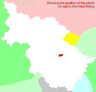
- For a detailed map of this parish see this parish boundaries map.
- For a more detailed map of the parishes in the riding please see the Yorkshire parish maps page.
- For a more detailed map of the county please see the Yorkshire map page.
- Here is a map showing the wapentakes for the county.
You can see maps centred on OS grid reference SE396269 (Lat/Lon: 53.73699, -1.401148), Methley which are provided by:
- OpenStreetMap
- Google Maps
- StreetMap (Current Ordnance Survey maps)
- Bing (was Multimap)
- Old Maps Online
- National Library of Scotland (Old Ordnance Survey maps)
- Vision of Britain (Click "Historical units & statistics" for administrative areas.)
- English Jurisdictions in 1851 (Unfortunately the LDS have removed the facility to enable us to specify a starting location, you will need to search yourself on their map.)
- Magic (Geographic information) (Click + on map if it doesn't show)
- GeoHack (Links to on-line maps and location specific services.)
- All places within the same township/parish shown on an Openstreetmap map.
- Nearby townships/parishes shown on an Openstreetmap map.
- Nearby places shown on an Openstreetmap map.
- The following places are within the boundaries of this (ancient) parish, but I have no further information on them other than the Ordnance Survey Landranger Grid reference shown:
- (SE409262) Dunford House
- (SE373260) Hungate
- (SE392260) Methley Junction
- (SE372255) Methley Lanes
- (SE396272) Mickletown
- (SE378257) Scholey Hill
- (SE385273) Wood Row
- This parish is covered (or partly covered) by the following Societies:
- A list of those paying the 1379 Subsidy Rolls (Poll Tax) for this parish.

