Hide
Rothwell
hide
Hide
hide
Hide
Hide
The Ancient Parish of ROTHWELL
[Transcribed information mainly from the early 1820s]
"ROTHWELL, a parish-town, in Agbrigg-division of Agbrigg and Morley, liberty of Pontefract; 4½ miles SW. of Leeds, 5½ from Wakefield, 28 from York. Pop. including Rothwell Haigh, and Roydes Green, 2,155. The Church is a vicarage, dedicated to the Holy Trinity, in the deanry of Pontefract, value, ~£19. 12s. 11d. Patron, Charles John Brandling, Esq."This place," says Whitaker's Loidis and Elmete, "appears to have been named when first planted by the Saxons, from a rapid and copious Well near the Church." It was distinguished among the numerous Manors of the Lacies, dependent on the Castle of Pontefract, by having a Castlet or Manor House near the Church, of which a mass of strong grout work yet remains.
The Church of Rothwell was appropriated to the Priory of Nostel, to which it was given, according to Burton, by Robert de Lacy. Here is a Charity School, founded by the late John Bromley, gentlemen, of Wakefield, in 1722."
Information on the following places in this Parish is contained on a supplementary page.
|
|
[Description(s) edited from various 19th century sources by Colin Hinson © 2013]
Hide
- There is a list of cemeteries (as opposed to Church Graveyards) for this area on the Leeds City Council's website.
- John Readman is transcribing the gravestones etc. at Holy Trinity, Rothwell.
- Graves in the North Section Rows A to K, and Rows K to V.
- Graves in the North West Section.
- Here are photographs of Churches etc. in the parish:
- Holy Trinity Church, Rothwell (view 1 showing the Lyche gate). (The Church's website is here.)
- Holy Trinity Church, Rothwell (view 2).
- The Baptist Church, Rothwell.
- The Roman Catholic Church, Rothwell.
- All Saints' Church, Woodlesford. This building is now a private dwelling.
- The Methodist Church, Woodlesford.
- The Church of St. John the Evangelist, Oulton.
- The Methodist Church, Oulton.
- Christ Church, Lofthouse. (The Church's website is here.)
- The Methodist Church, Lofthouse.
- The Church of St John and St Barnabas, Belle Isle.
- St. Peter's Roman Catholic Church, Belle Isle. (With short history).
- The Church of St. Mary the Virgin, Middleton.
- St. Cross's Church, Middleton.
- The Methodist Church, Middleton.
- Middleton Park Baptist Church, Middleton.
- St. Philip's Roman Catholic Church, Middleton.
- The former Wesleyan Methodist Church, Thorpe on the Hill.
- Transcript of the entry for Rothwell in the "Collections relative to Churches and Chapels".
- Transcript of the entry for Oulton in the "Collections relative to Churches and Chapels".
- Transcriptions of the Burials for the Parish of Rothwell by Carol Ryan. 1785-1790, 1790-1795, 1795-1800.
- The whereabouts and dates of the Registers etc. for the Parish of Rothwell.
- The whereabouts and dates of the Registers etc. for the Chapelry of Oulton cum Woodlesford.
- Transcript of the entry of "professions and trades" in the Baines's Directory and Gazetteer, Vol I, West Riding.
- Transcript of the entry of "professions and trades" in the Pigot's 1834 Directory, Yorkshire section.
- There is further information about this parish from the Pigot's 1834 Directory, Yorkshire section.
- There is further information about this parish from the National Gazetteer 1868, Yorkshire extracts.
- There is further information about this parish from the Lewis's Topographical Dictionary of England, Yorkshire extracts.
- There is further information about this parish from the Stephen Whatley's Gazetteer 1750, Yorkshire extracts.
- Ask for a calculation of the distance from Rothwell to another place.

- For a detailed map of this parish see this parish boundaries map.
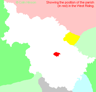
- For a more detailed map of the parishes in the riding please see the Yorkshire parish maps page.
- For a more detailed map of the county please see the Yorkshire map page.
- Here is a map showing the wapentakes for the county.
You can see maps centred on OS grid reference SE344285 (Lat/Lon: 53.751738, -1.479798), Rothwell which are provided by:
- OpenStreetMap
- Google Maps
- StreetMap (Current Ordnance Survey maps)
- Bing (was Multimap)
- Old Maps Online
- National Library of Scotland (Old Ordnance Survey maps)
- Vision of Britain (Click "Historical units & statistics" for administrative areas.)
- English Jurisdictions in 1851 (Unfortunately the LDS have removed the facility to enable us to specify a starting location, you will need to search yourself on their map.)
- Magic (Geographic information) (Click + on map if it doesn't show)
- GeoHack (Links to on-line maps and location specific services.)
- All places within the same township/parish shown on an Openstreetmap map.
- Nearby townships/parishes shown on an Openstreetmap map.
- Nearby places shown on an Openstreetmap map.
- The World War I memorial for Oulton and Woodlesford
- The World Wars I and II memorial at Rothwell
- The following places are within the boundaries of this (ancient) parish, but I have no further information on them other than the Ordnance Survey Landranger Grid reference shown:
- (SE313293) Belle Isle
- (SE351291) John o' Gaunts
- (SE339264) Ouzlewell Green
- (SE323276) Robin Hood
- (SE325305) Stourton
- Rothwell and District Historical Society
- Members who have a vast historical knowledge of Rothwell and surrounding areas formed the society twelve years ago. Our aim is to promote and preserve historical items and stories for future generations. We have a local history collection that is growing day by day. We meet the second Friday of every month, (except August) with a guest speaker, in the Rothwell Methodist Hall, Butcher Lane.
- This parish is covered (or partly covered) by the following Societies:
- A list of those paying the 1379 Subsidy Rolls (Poll Tax) for this parish.

