Hide
Sandal Magna
hide
Hide
hide
Hide
Hide
The Ancient Parish of SANDAL MAGNA
[Transcribed information mainly from the early 1820s]
"SANDAL MAGNA, a parish-town, in Agbrigg-division of Agbrigg and Morley, liberty of Wakefield, 2 miles from Wakefield, 8 from Barnsley, 9 from Pontefract, 30 from York. Pop. 888. The Church is a vicarage, dedicated to St. Helen, in the deanry of Pontefract, value, ~£13. 7s. 8d. p.r. £122. 17s. 2d. Patron, the King.The Castle here, was built by John, Earl of Warren, about the year 1320. In the reign of Edward III. Edward Baliol resided here, while an army was raising to establish him on the throne of Scotland. This Castle afterwards became the property of Richard Plantagenet, Duke of York, who was slain in a great battle, fought near this place, in the year 1460. The last siege it sustained was in the civil wars of Charles I.; Col. Bonivant held it for the King, and surrendered to the arms of Parliament, in the month of October, 1645. In the following year it was dismantled, by the order of Parliament.
Thomas Zouch, D.D. a man of considerable erudition, was born here in 1737. A collection of his works, with a memoir by the Rev. Thomas Wrangham, was published in 1820.
Here is a Free School for eight Boys, founded by the late Rev. Doctor Zouch, who endowed it with £10. per annum, and a House and Garden."
Information on the following places in this Parish is contained on a supplementary page.
|
|
|
[Description(s) edited from various 19th century sources by Colin Hinson © 2013]
Hide
- Here are photographs of Churches etc. in the parish:
- St. Helen's Church, Sandal Magna.
- The Primitive Methodist Church, Durkar.
- The Church of St. John the Divine, Calder Grove.
- St. James's Church, Chapelthorpe.
- Lakeside Methodist Church, Newmillerdam.
- The Roman Catholic Church of St. Peter and St. Paul, Stand Bridge. (The Church's website is here.)
- St. Paul's Church, Walton. (The Church's website is here.)
- The Methodist Church, Sandal Magna. (The Church's website is here.)
- Wakefield Baptist Church, Sandal Magna. (The Church's website is here.)
- St. Catherine's Church and day centre, Belle Vue. (The Church's website is here.)
- A transcription of Crigglestone Baptist Church History
- Transcript of the entry for Sandal Magna in the "Collections relative to Churches and Chapels".
- Transcript of the entry for Chapelthorpe in the "Collections relative to Churches and Chapels".
- The whereabouts and dates of the Registers etc. for the Parish of Sandal Magna.
- The whereabouts and dates of the Registers etc. for the Chapelry of Chapel Thorpe.
- Transcript of the entry of "professions and trades" in the Baines's Directory and Gazetteer, Vol I, West Riding.
- Transcript of the entry of "professions and trades" in the White's General and Commercial Directory, of Wakefield, Horbury, Alverthorpe, Sandal Magna, Stanley and Normanton - 1887
- There is further information about this parish from the Pigot's 1834 Directory, Yorkshire section.
- There is further information about this parish from the National Gazetteer 1868, Yorkshire extracts.
- There is further information about this parish from the Lewis's Topographical Dictionary of England, Yorkshire extracts.
- There is further information about this parish from the White's General and Commercial Directory, of Wakefield, Horbury, Alverthorpe, Sandal Magna, Stanley and Normanton - 1887
- Ask for a calculation of the distance from Sandal Magna to another place.
- History of the parish of Sandal Magna by Angela Petyt
- History of the village of Crigglestone by Keith Wainwright
- Sandal Castle - history and photos

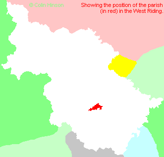
- For a detailed map of this parish see this parish boundaries map.
- For a more detailed map of the parishes in the riding please see the Yorkshire parish maps page.
- For a more detailed map of the county please see the Yorkshire map page.
- Here is a map showing the wapentakes for the county.
You can see maps centred on OS grid reference SE342182 (Lat/Lon: 53.659178, -1.483964), Sandal Magna which are provided by:
- OpenStreetMap
- Google Maps
- StreetMap (Current Ordnance Survey maps)
- Bing (was Multimap)
- Old Maps Online
- National Library of Scotland (Old Ordnance Survey maps)
- Vision of Britain (Click "Historical units & statistics" for administrative areas.)
- English Jurisdictions in 1851 (Unfortunately the LDS have removed the facility to enable us to specify a starting location, you will need to search yourself on their map.)
- Magic (Geographic information) (Click + on map if it doesn't show)
- GeoHack (Links to on-line maps and location specific services.)
- All places within the same township/parish shown on an Openstreetmap map.
- Nearby townships/parishes shown on an Openstreetmap map.
- Nearby places shown on an Openstreetmap map.
- Transcription and photograph of Memorial at Manygates to Richard Duke of York killed at the Battle of Wakefield 1460
- Transcription and photograph of Sandal St. Helen's Church War Memorial
- Transcription of Sandal Wesleyan Methodist Church War Memorial
- Transcription and photograph of Belle Vue St. Catherine's Church War Memorial
- Transcription and photograph of Crigglestone War Memorial
- Transcription and photograph of Hall Green Mount Zion Methodist Church War Memorial
- Transcription and photograph of Newmillerdam War Memorial
- Transcription and photograph of Walton War Memorial
- The following places are within the boundaries of this (ancient) parish, but I have no further information on them other than the Ordnance Survey Landranger Grid reference shown:
- (SE306167) Calder Grove
- (SE277174) Coxley
- (SE304160) Great Cliff
- (SE329165) Kettlethorpe
- (SE356165) Overtown
- (SE335187) Portobello
- (SE339180) Sandal
- (SE337179) Sandal Castle
- (SE344170) Woolgreaves
- This parish is covered by the following Society:
- A list of those paying the 1379 Subsidy Rolls (Poll Tax) for this parish.

