Hide
Spofforth
hide
Hide
hide
Hide
Hide
The Ancient Parish of SPOFFORTH
[Transcribed information mainly from the early 1820s]
"SPOFFORTH, a parish-town, in the upper-division of Claro; 3 miles NW. of Wetherby, 4 from Knaresborough, 5 from Harrogate, 18 from York. Pop. 895. The Church is a rectory, dedicated to All-Saints (see Churches for photograph), in the deanry of the Ainsty, value, £73. 6s.8d. Patron, the Earl of Egremont.Spofforth Castle is remarkable for having been, for several ages, the principal seat of the noble family of Percy; and still continues in the possession of one of its descendants, the Earl of Egremont. This Castle is supposed to have been built in the time of Edward III. and is at present in a dilapidated state, but yet displays strong marks of a rude and grand mansion. After the battle of Towton, so fatal to Henry VI. in which were slain the Earl of Northumberland and Sir Richard Percy, his brother, their estates were laid waste by the enraged conquerors; and this Mansion was dismantled, and reduced from a princely palace to a heap of ruins. --Archaeol. --Hargrove.
Here was born, Lawrence Eusden, a poet, and educated at Trinity College, Cambridge. In 1718, he obtained the Laureatship, which raised him several enemies, particularly Pope, who placed him in the Dunciad. His poems are in Nichols' Collection. He died in 1730. --Gen. Biog. Dict."
Information on the following places in this Parish is contained on a supplementary page.
|
|
|
[Description(s) edited from various 19th century sources by Colin Hinson © 2013]
Hide
- Here are photographs of Churches in the parish:
- All Saints' Church, Spofforth (view 1).
- All Saints' Church, Spofforth (view 2).
- Internal view looking down the nave
- St. James' Church, Wetherby.
- St. James' Church On the Corner, Wetherby (view 1).
- St. James' Church On the Corner, Wetherby (view 2).
- The Methodist Church, Wetherby (originally Wesleyan, built in 1829). (The Church's website is here.)
- St. Joseph's Roman Catholic Church, Wetherby.
- St. Joseph and St. James' Church, Follifoot.
- The Methodist Church, Little Ribston, opened 1818.
- Transcript of the entry for Spofforth in the "Collections relative to Churches and Chapels".
- Transcript of the entry for Wetherby in the "Collections relative to Churches and Chapels".
- The following entries in the Parish registers for Burials at Wetherby have been transcribed:
- The whereabouts and dates of the Registers etc. for the Parish of Spofforth.
- The whereabouts and dates of the Registers etc. for the Chapelry of Wetherby.
- The List of Rectors of St. All Saint's Church, Spofforth.
- Transcript of the entry of "professions and trades" in the Baines's Directory and Gazetteer, Vol I, West Riding.
- Transcript of the entry of "professions and trades" in the Pigot's 1829 Directory, Yorkshire section.
- Transcript of the entry of "professions and trades" in the Pigot's 1834 Directory, Yorkshire section.
- Transcript of the entry of "professions and trades" in the White's 1837 Gazetteer, History and Directory, of the West Riding.
- There is further information about this parish from the Pigot's 1829 Directory, Yorkshire section.
- There is further information about this parish from the Pigot's 1834 Directory, Yorkshire section.
- There is further information about this parish from the White's 1837 Gazetteer, History and Directory, of the West Riding.
- There is further information about this parish from the National Gazetteer 1868, Yorkshire extracts.
- There is further information about this parish from the Lewis's Topographical Dictionary of England, Yorkshire extracts.
- There is further information about this parish from the Stephen Whatley's Gazetteer 1750, Yorkshire extracts.
- Ask for a calculation of the distance from Spofforth to another place.

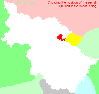
- For a detailed map of this parish see this parish boundaries map.
- For a more detailed map of the parishes in the riding please see the Yorkshire parish maps page.
- For a more detailed map of the county please see the Yorkshire map page.
- Here is a map showing the wapentakes for the county.
You can see maps centred on OS grid reference SE364510 (Lat/Lon: 53.953821, -1.44681), Spofforth which are provided by:
- OpenStreetMap
- Google Maps
- StreetMap (Current Ordnance Survey maps)
- Bing (was Multimap)
- Old Maps Online
- National Library of Scotland (Old Ordnance Survey maps)
- Vision of Britain (Click "Historical units & statistics" for administrative areas.)
- English Jurisdictions in 1851 (Unfortunately the LDS have removed the facility to enable us to specify a starting location, you will need to search yourself on their map.)
- Magic (Geographic information) (Click + on map if it doesn't show)
- GeoHack (Links to on-line maps and location specific services.)
- All places within the same township/parish shown on an Openstreetmap map.
- Nearby townships/parishes shown on an Openstreetmap map.
- Nearby places shown on an Openstreetmap map.
- The World War I Memorial Plaque in St. James Church, Wetherby.
- The World War II Memorial Plaque in St. James's Church, Wetherby.
- The World War I Memorial Plaque in All Saints Church, Spofforth.
- The World War II Memorial Plaque in All Saints Church, Spofforth.
- The World War I memorial on Boston Road, Wetherby.
- The following places are within the boundaries of this (ancient) parish, but I have no further information on them other than the Ordnance Survey Landranger Grid reference shown:
- (SE348522) Aketon Lodge
- (SE323522) Follifoot Ridge
- (SE387480) Linton Hills
- (SE363549) Low Grange
- (SE357541) Plompton Hall
- (SE362537) Plompton High Grange
- (SE359534) Plompton Square
- (SE368502) Spofforth Hall
- (SE377498) Stockeld Grange
- (SE372492) Stockeld Park
- (SE385475) Westwood
- This parish is covered (or partly covered) by the following Societies:
- A list of those paying the 1379 Subsidy Rolls (Poll Tax) for this parish.

