Skip to main content
hide
Hide
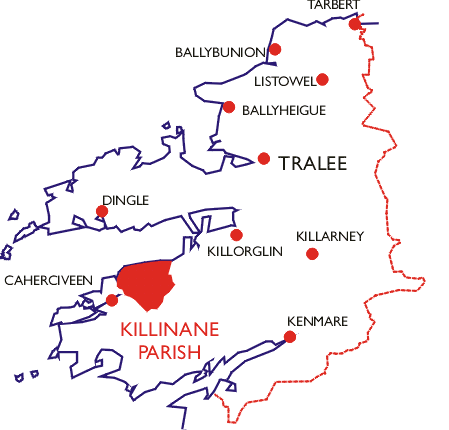
Location Map of Killinane Parish
" This parish is bounded on the north and north-west by the Bay of Dingle, on the east by the parish of Glenbeagh, on the south by that of Drummod, and on the west by that of Caher."
[From The Antiquities of County Kerry by John O'Donovan (1841)]
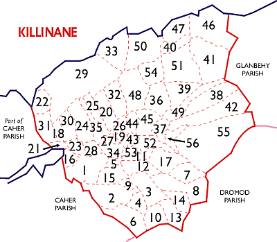
Townlands of Killinane Parish
| Number | Townland | DED |
|---|
| 1 | Bahaghs | Bahaghs |
| 2 | Cappagh | Bahaghs |
| 3 | Coars | Bahaghs |
| 4 | Coomdeeween | Bahaghs |
| 5 | Coumduff | Bahaghs |
| 6 | Derrymore | Bahaghs |
| 7 | Garrane North | Bahaghs |
| 8 | Garrane South | Bahaghs |
| 9 | Glebe | Bahaghs |
| 10 | Keelnagore | Bahaghs |
| 11 | Killognaveen North | Bahaghs |
| 12 | Killognaveen South | Bahaghs |
| 13 | Knockaneden | Bahaghs |
| 14 | Raheens | Bahaghs |
| 15 | Srugreana | Bahaghs |
| 16 | Strandsend | Bahaghs |
| 17 | Teernahila | Bahaghs |
| 18 | Ballydarrig | Castlequin |
| 19 | Ballynahow Beg | Castlequin |
| 20 | Ballynahow More | Castlequin |
| 21 | Cloghane | Castlequin |
| 22 | Coomnahincha | Castlequin |
| 23 | Deelis | Castlequin |
| 24 | Dooneen | Castlequin |
| 25 | Foilduff | Castlequin |
| 26 | Foilmore | Castlequin |
| 27 | Gortmore | Castlequin |
| 28 | Inchintrea | Castlequin |
| 29 | Killurly Commons | Castlequin |
| 30 | Killurly East | Castlequin |
| 31 | Killurly West | Castlequin |
| 32 | Lisbane | Castlequin |
| 33 | Roads | Castlequin |
| 34 | Teeraha | Castlequin |
| 35 | Tullig | Castlequin |
| 36 | Boulerdah | Killinane |
| 37 | Cahereighterrush | Killinane |
| 38 | Caherlehillan | Killinane |
| 39 | Cahernaman | Killinane |
| 40 | Cappamore | Killinane |
| 41 | Coomshanna | Killinane |
| 42 | Coulagh | Killinane |
| 43 | Derrenmouria | Killinane |
| 44 | Dromtea | Killinane |
| 45 | Garrydine | Killinane |
| 46 | Gleensk | Killinane |
| 47 | Gortaforia | Killinane |
| 48 | Gortnagree | Killinane |
| 49 | Gortnagulla | Killinane |
| 50 | Kells | Killinane |
| 51 | Knockaneyouloo | Killinane |
| 52 | Liss Lower | Killinane |
| 53 | Liss Upper | Killinane |
| 54 | Reacaslagh | Killinane |
| 55 | Teeromoyle | Killinane |
| 56 | Toon | Killinane |