
Hide
Lavernock
hide
Hide
hide
Hide
hide
Hide
Hide
"LLAFERNOC, in the Cwmwd of Is Caeth, Cantref of Brenhinol (now called the Hundred of Dinas Powys), Co. of GLAMORGAN, South Wales: a Rectory, not in charge, annexed to the Vicarage of Pen Arth: Patron, the Earl of Plymouth, under Lease with the Tythes from The Dean and Chapter of Bristol: Church dedicated to St. Laurence. The Resident Population of this Parish, in 1801, was 54. The money raised by the Parish Rates, in 1803, was £46..15..2, at 6s. 9d. in the pound. It is 10 m. S. S. W. from Caerdiff. This Parish contains nearly 800 acres of Land. It is situate upon the Bristol Channel. The name signifies, a Low Hill washed by the Sea." From: A Topographical Dictionary of The Dominion of Wales by Nicholas Carlisle, London, 1811.
"LAVERNOCK, otherwise LARNOCK, a parish in the hundred of DINAS-POWIS, county of GLAMORGAN, SOUTH WALES, 7 1/2 miles (S. by W.) from Cardiff, containing 77 inhabitants. The living is a rectory not in charge, consolidated with the vicarage of Penarth, in the archdeaconry and diocese of Llandaf. The church, dedicated to St. Lawrence, is situated close to the edge of the water, the parish lying on the shore of the Bristol channel. Lead-ore has been obtained here, but the works are now discontinued : the principal substratum is lyas limestone, in which the usual fossils abound : in the cliffs under this limestone are found tripoli, and lapis cariosus, or rotten stone, intermingled with a red marly earth, in which are imbedded blocks of gypseous alabaster. The average annual expenditure for the maintenance of the poor is £27. 10." ( A Topographical Dictionary of Wales by Samuel Lewis 1833)
Hide
Here is a substantial reading list of books which relate to Glamorgan, either county or parish.
The Glamorgan Family History Society have produced a set of microfiche containing Monumental Inscriptions for the following burial grounds :-
- Parish Church of St. Lawrence
| St Lawrence / St Laurence, Lavernock |
Glamorgan Chapels Database- None found in this parish
For full and up-to-date details of their holdings see the sites of Glamorgan Record Office and/or West Glamorgan Archives
See Bap/Mar/Bur data on FreeReg
The church is dedicated to St. Lawrence, is in the Benefice of Penarth with Lavernock, and the diocese of Llandaff. Details of the present incumbent of this benefice can be found at the Church in Wales website. The church can be located at grid reference ST187682.
A transcription of the registers is available from the Glamorgan Family History Society for the years: Baptisms, 1724-1904, Marriages, 1725-1836, Burials, 1724-1902. Visit their website for information on how to purchase these fiche.
| Anglican Parish Registers Held at the Glamorgan Record Office, Cardiff | ||||
| Baptisms | Marriages | Burials | Banns | Bishops Transcripts |
| 1769-1956 | 1769-1836, 1842-1902 | 1778-1812, 1821-1964 | 1883-1943 | 1724-1727, 1729-1830, 1832-1837 |
Details of extant records on Archives Network Wales for the following;
- Lavernock Ecclesiastical Parish records " .......... including registers of baptisms, 1769-1956; marriages, 1769-1902; burials, 1778-1964; parish transcripts, made in 1980"
The following Religious Institutions are covered in the Mormon International Genealogical Index (IGI) :-
- Lavernock, St. Lawrence - Christenings (BT's), 1819-1875
Lavernock Point - on Wikipedia ; also Lavernock Battery
Cosmeston Lakes & Medieval Village - on Wikipedia & on the Abandoned Villages site
Various landscapes - on the People's Collection Wales site
The transcription of the section for Lavernock from The National Gazetteer (1868) provided by Colin Hinson.
- Ask for a calculation of the distance from Lavernock to another place.
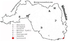
This diagram shows the position of this parish within the county of Glamorgan - click on this to see a full size diagram of the county
|
Parish of Lavernock in the County of Glamorgan - on the People's Collection Wales site
Parish map (Kain/Oliver)
You can see maps centred on OS grid reference ST177686 (Lat/Lon: 51.410556, -3.184019), Lavernock which are provided by:
- OpenStreetMap
- Google Maps
- StreetMap (Current Ordnance Survey maps)
- OpenStreetMap Cymru (Welsh counties only)
- Bing (was Multimap)
- Old Maps Online
- National Library of Scotland (Old Ordnance Survey maps)
- Vision of Britain (Click "Historical units & statistics" for administrative areas.)
- Magic (Geographic information) (Click + on map if it doesn't show)
- GeoHack (Links to on-line maps and location specific services.)
- All places within the same township/parish shown on an Openstreetmap map.
- Nearby townships/parishes shown on an Openstreetmap map.
- Nearby places shown on an Openstreetmap map.
Places, villages, farms etc within Lavernock parish as shown on the online parish map from the CD of Historic Parishes of England and Wales: an Electronic Map of Boundaries before 1850 with a Gazetteer and Metadata [computer file]. (Kain, R.J.P., Oliver, R.R.). (Extracted by Gareth Hicks)
- Lavernock (182); Castle; Cement & Lime Works; Cosmeston; Lavernock; Lavernock Ho.; Lavernock Point; Ranny Bay; Roundbush Rocks; St Marys Well Bay; Sutton; Swanbridge
The Population of Lavernock was as follows, and a more detailed breakdown is available.
| 1841 - 85 | 1851 - 81 | 1861 - 89 | 1871 - 109 | 1881 - 81 | 1891 - 78 |
Details of extant records on Archives Network Wales for the following;
- Lavernock Civil Parish records " ........ including land tax assessment, 1877; assistant overseers' rate books, 1897-1926; assistant overseers' receipt and payment books, 1918-1927, copies of tithe plan and apportionment, c1840"