
Hide
Leckwith
hide
Hide
hide
Hide
hide
Hide
Hide
"LLECH WEDD, in the Cwmwd of Is Caeth, Cantref of Brenhinol (now called the Hundred of Dinas Powys), Co. of GLAMORGAN, South Wales: a discharged Rectory, with the Rectory of Llan Doch: Patron, The Marquis of Bute: Church dedicated to St. James. The Resident Population of this Parish, in 1801, was 74. The money raised by the Parish Rates, in 1803, was £70..10..10, at 3s. 9d. in the pound. It is 2 m. W. from Caerdiff. This Parish contains nearly 1000 acres of Land, all cultivated. It is situate on the River Elay."
From: A Topographical Dictionary of The Dominion of Wales by Nicholas Carlisle, London, 1811.
"LECKWITH (LLECHWEDD, or LLECH-WYDD), a parish in the hundred of DINAS-POWIS, county of GLAMORGAN, SOUTH WALES, 2 1/2 miles (W. S. W.) from Cardiff, containing 112 inhabitants. This parish, of which the name signifies "the slope of the cliff," is situated on the river Ely, over which is a bridge of two arches. Limestone of good quality is found here in great abundance, and large quantities are quarried for building purposes, and also burnt as an article of manure for the supply of the surrounding neighbourhood. The village is situated on an eminence overlooking the marshes which intervene between it and Cardiff, and from Leckwith hill are some interesting and extensive views. The inhabitants are, from the exhalations rising from the lower grounds, subject to ague. The living, with Llandough and Cogan, forms a consolidated discharged rectory, in the archdeaconry and diocese of Llandaf, rated in the king's hooks at £8. 8. 4., and in the patronage of the Marquis of Bute. The church, which is remarkable for the simplicity of its style, is dedicated to St. James, and stands upon a high bank above the marshes. The poor children of the parish are gratuitously instructed in the National school at Llandough. The average annual expenditure for the support of the poor is £ 146. 1." A Topographical Dictionary of Wales (1833) by Samuel Lewis.
Hide
Here is a substantial reading list of books which relate to Glamorgan, either county or parish.
The Glamorgan Family History Society have produced a set of microfiche containing Monumental Inscriptions for the following burial grounds :-
- Parish Church of St. James
| St James, Leckwith |
Glamorgan Chapels Database- None found in this parish
For full and up-to-date details of their holdings see the sites of Glamorgan Record Office and/or West Glamorgan Archives
See Bap/Mar/Bur data on FreeReg
The church is dedicated to St. James.
A transcription of the registers is available from the Glamorgan Family History Society for the years: Baptisms, 1724-1880, Marriages, 1725-1838, Burials, 1724-1880. Visit their website for information on how to purchase these fiche.
| Anglican Parish Registers Held at the Glamorgan Record Office, Cardiff | ||||
| Baptisms | Marriages | Burials | Banns | Bishops Transcripts |
| 1781-1966 | 1781-1810, 1813-1963 | 1781-1986 | 1823-1959 | 1724-1752, 1754-1769, 1771-1841 |
The following Religious Institutions are covered in the Mormon International Genealogical Index (IGI) :-
- Leckwith, St. James - Christenings (BT's), 1724-1875
Transcript of name listing for Cardiff, from Commercial and Trade Directories, for the years:-
| 1880 | (Slater's Directory) (302k) |
The transcription of the section for Leckwith from The National Gazetteer (1868) provided by Colin Hinson.
- Ask for a calculation of the distance from Leckwith to another place.
The Manor of Leckwith - from Cardiff Records, Volume II, Chapter I NOTES ON THE MANORS OF THE CARDIFF DISTRICT . (British History Online)
Minister's Account for the Lordship of Leckwith 1456 - on British History Online
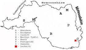
This diagram shows the position of this parish within the county of Glamorgan - click on this to see a full size diagram of the county
|
Plan of the parishes of Landough, Cogan and Leckwith, Glamorganshire - on the People's Collection Wales site
Parish map (Kain/Oliver)
You can see maps centred on OS grid reference ST153750 (Lat/Lon: 51.467694, -3.221054), Leckwith which are provided by:
- OpenStreetMap
- Google Maps
- StreetMap (Current Ordnance Survey maps)
- OpenStreetMap Cymru (Welsh counties only)
- Bing (was Multimap)
- Old Maps Online
- National Library of Scotland (Old Ordnance Survey maps)
- Vision of Britain (Click "Historical units & statistics" for administrative areas.)
- Magic (Geographic information) (Click + on map if it doesn't show)
- GeoHack (Links to on-line maps and location specific services.)
- All places within the same township/parish shown on an Openstreetmap map.
- Nearby townships/parishes shown on an Openstreetmap map.
- Nearby places shown on an Openstreetmap map.
Places, villages, farms etc within Leckwith parish as shown on the online parish map from the CD of Historic Parishes of England and Wales: an Electronic Map of Boundaries before 1850 with a Gazetteer and Metadata [computer file]. (Kain, R.J.P., Oliver, R.R.). (Extracted by Gareth Hicks) [NB; the boundary between Llandaff and Leckwith parishes is missing on the map, allocation between them may not be 100% accurate therefore]
- Leckwith (149); Bryn-well; Course; Ely River; Leckwith (village); Leckwith Bridge Ho.; Rectory?; Res.; White Fm.; Woodlands; Ynis ...? Fm.;
The Population of Leckwith was as follows, and a more detailed breakdown is available.
| 1841 - 121 | 1851 - 114 | 1861 - 133 | 1871 - 169 | 1881 - 177 | 1891 - 122 |
Details of extant records on Archives Network Wales for the following;
- Leckwith Civil Parish records " ......... including bastardy bonds, 1794; assistant overseers' rate book, 1920-1926; assistant overseers' receipt and payment book, 1919-1927; parish meeting minutes book, 1894-1959"