
Hide
Llantwit Fardre
hide
Hide
hide
Hide
hide
Hide
Hide
"LANTWIT FAYRDRE, in the Cwmwd of Meisgyn, Cantref of Penythen (now called the Hundred of Miskin), Co. of GLAMORGAN, South Wales: a Curacy, not in charge, to the Vicar of Llan Trisaint. The Resident Population of this Parish, in 1801, was 405. The Money raised by the Parish Rates, in 1803, was £238..0..0 1/2. It is 2 m. N. b. E. from Llant Trisaint. According to the Diocesan Report, in 1809, the yearly value of this Benefice, arising from Augmentation (no Stipend), was £32." From: A Topographical Dictionary of The Dominion of Wales by Nicholas Carlisle, London, 1811
Hide
Here is a substantial reading list of books which relate to Glamorgan, either county or parish.
References to Llantwit Fardre at the British Library, London
Pontypridd at War 1939-45, the Second World War at home by Don Powell [1999]
Victorian Pontypridd and its villages by Don Powell [1996]
The Glamorgan Family History Society have produced a set of microfiche containing Monumental Inscriptions for the following burial grounds :-
- Parish Church of St. Illtyd
Chapels Database - a list of all known non-conformist chapels or other non-Anglican religions in the parish
See John Ball's site Welsh Churches and Chapels Collection for a photograph/data re St Illtud's Church
See Welsh Chapels and Churches for photographs of various churches/chapels in this parish
Various items - on the People's Collection Wales site
- View from the road junction looking toward the church tower.St Illtud’s church is a medieval church on an ancient Celtic site.
- St Andrews Church, Llantwit Fardre.
- St Illtyds choir, Llantwit Fardre, 1970s
For full and up-to-date details of their holdings see the sites of Glamorgan Record Office and/or West Glamorgan Archives
See Bap/Mar/Bur data on FreeReg
The church is dedicated to St. Illtyd, and is in the Benefice of Llantwit Fardre. Details of the present incumbent of this benefice can be found at the Church in Wales website. The church can be located at grid reference ST082866.
A transcription of the registers is available from the Glamorgan Family History Society for the years: Baptisms, 1632-1850, Marriages, 1625-1837, Burials, 1632-1857.
| Anglican Parish Registers Held at the Glamorgan Record Office, Cardiff | ||||
| Baptisms | Marriages | Burials | Banns | Bishops Transcripts |
| 1626-1835, 1837-1840, 1846-1934 | 1626-1972 | 1626-1832, 1834, 1837-1843, 1846-1949 | 1947-1959 | 1717, 1724-1739, 1741-1774, 1776-1828, 1831-1832, 1837 |
Details of extant records on Archives Network Wales for the following;
- Llantwit Fardre Ecclesiastical Parish records " ....... including registers of banns, 1947-1959; services, 1904-1968; baptisms, 1626-1934; burials, 1626-1949; marriages, 1626-1972; records relating to: parochial church council, 1920-1928; church events, 1926; churchwardens, 1876-1928; vestry council, 1877-1923; church affairs, 1913-1922; civil and miscellaneous, 1792-1924"
Modern Parishes & Chapels of Ease :-
- St. Mary, Glyntaff - Parish formed in 1848 from Eglwysilan, Llanwonno and Llantwit Fardre
- St. John, Graig
- St. Catherine, Pontypridd
- St. David, Pontypridd
- St. Matthew, Pontypridd
| Non Conformist Registers Deposited at the Glamorgan Record Office, Cardiff | ||||
| Chapel | Baptisms | Marriages | Burials | OS Map Ref |
| Trinity, Calvinistic Methodist | - | 1922-1984 | - | ST 07468503 |
The following Religious Institutions are covered in the Mormon International Genealogical Index (IGI) :-
- Llantwit Fardre, St. Illtyd - Christenings (BT's), 1813-1874
Details of extant records on Archives Network Wales for the following;
- Llantwit Fardre Parish photographs "The archive comprises photographs collected by Dillwyn Lewis for inclusion in his publication, Under the Parish Lantern. They include photographs, with annotations, of places within, and events held in the parish of Llantwit Fardre, including the towns and villages of Church Village, Tonteg, Llantwit Fardre, Efail Isaf, Treforest and Creigiau"
The transcription of the section for Llantwit Fardre from The National Gazetteer (1868) provided by Colin Hinson.
Description of parish from A Topographical Dictionary of Wales (1833) by Samuel Lewis.
- Ask for a calculation of the distance from Llantwit Fardre to another place.
Some of the hamlets, towns and villages within this parish
|
|
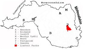
This diagram shows the position of this parish within the county of Glamorgan - click on this to see a full size diagram of the county
|
Parish map (Kain/Oliver)
You can see maps centred on OS grid reference ST089864 (Lat/Lon: 51.558087, -3.334245), Llantwit Fardre which are provided by:
- OpenStreetMap
- Google Maps
- StreetMap (Current Ordnance Survey maps)
- OpenStreetMap Cymru (Welsh counties only)
- Bing (was Multimap)
- Old Maps Online
- National Library of Scotland (Old Ordnance Survey maps)
- Vision of Britain (Click "Historical units & statistics" for administrative areas.)
- Magic (Geographic information) (Click + on map if it doesn't show)
- GeoHack (Links to on-line maps and location specific services.)
- All places within the same township/parish shown on an Openstreetmap map.
- Nearby townships/parishes shown on an Openstreetmap map.
- Nearby places shown on an Openstreetmap map.
Places, villages, farms etc within Llantwit Fardre as shown on the online parish map from the CD of Historic Parishes of England and Wales: an Electronic Map of Boundaries before 1850 with a Gazetteer and Metadata [computer file]. (Kain, R.J.P., Oliver, R.R.). (Extracted by Glenys Travis)
- Llantwit-Fardre[82] - Berth-bryd, Church Village, Coedcae-du, Coed-y-Gedrys, Croesged Ho, Croesged, Cwm, Disgwylfa, Dowlais Brook, Drysgoed, Dyhewyd-Foel, Efail-Isaf, Garth, Gedrys, Gelli-draws, Gwaun-y-celyn, Hendre-scuthan, Isolation Hospital, Lan, Llantwit, Llantwit-Fardre, Maendy, Maes-bach, Nant Ifan-ddu, Newtown, Pentwyn, Pen-y-coedcae, Pen-y-rhiw, Taff Vale, The Cottage, Tonteg, Tre-forest, Twyn Maes y-grug, Ty-llwyd, Ty'r arlwydd, Ty'r Person, Ystrad-barwig-isaf, Ystrad-barwig-uchaf.
Sundry items - on the People's Collection Wales site
- Cwm Colliery was one of the Great Western Colliery Company's pits. This picture shows some colliers underground.
- Colour transparency showing view of Cwm Coking Works, Llantwit Farde, produced by Fleur James, 2005.
The Population of Llantwit Fardre was as follows, and a more detailed breakdown is available.
| 1841 - 2,192 | 1851 - 4,096 | 1861 - 4,415 | 1871 - 5,024 | 1881 - 5,829 | 1891 - 8,845 |
Details of extant records on Archives Network Wales for the following;
- Llantrisant and Llantwit Fardre Rural District Council records "Records of the Llantrisant and Llantwit Fardre Rural District Council, 1852-1977: minutes 1895-1964; committee minutes, 1920-1948; reports of the medical officer of health, 1916-1962; bye-laws, 1902-1956; Home Office orders, 1894-1898; local and personal acts relating to the Llantrisant area, 1852-1917; papers concerning the Ely Valley Sewerage Scheme, 1911; papers relating to the 'Llantrisant New Town Inquiry,' 1972; and photographs with related correspondence, 1968-1977"
- Llantwit Fardre Civil Parish records 1736-1974 "......... comprising overseers', churchwardens and highway surveyors' account books, 1736-1860; overseers' receipt and payment books, 1836-1859; vestry minutes books, 1848-1894; highway surveyors rate book, 1855; annual parish meeting minutes book, 1894-1919; tithe plan and apportionment, 1844; parish council minutes books, 1895-1952; parish council declarations of acceptance of office books, 1895-1939; parish council receipt and payment book, 1895-1905; parish council letter book, 1938-1945; land tax assessment, 1815; miscellaneous records, 1875-1974"
Details of extant records on Archives Network Wales for the following;
- Llantwit Fardre School Board records " .......... comprising of minute books, 1871-1903; letter book 1898-1902; cash book, 1900-1903; copy assignment of lease, 1873"