
Hide
Pendoylan
hide
Hide
hide
Hide
hide
Hide
Hide
"PEN DEULWYN, in the Cwmwd of Pen y Bont, Cantref of Cron Nedd (now called the Hundred of Cowbridge), County of GLAMORGAN, South Wales: a discharged Vicarage valued in the King's Books at £8..13..4: Patrons, The Chapter of Llandaff: Church dedicated to St. Cadog. The Resident Population of this Parish, in 1801, was 283. The Money raised by the Parish Rates, in 1803, was £221..5..5, at 5s. in the pound. It is 4 m. E. N. E. from Cowbridge. This Parish contains about 2500 acres of Land, all inclosed and cultivated. It is situate upon the river Elay. According to the Diocesan Report, in 1809, the yearly value of this Benefice, arising from Tythes, and Rent of Glebe, was £143..13..11."
From: A Topographical Dictionary of The Dominion of Wales by Nicholas Carlisle, London, 1811
Hide
Here is a substantial reading list of books which relate to Glamorgan, either county or parish.
The Glamorgan Family History Society have produced a set of microfiche containing Monumental Inscriptions for the following burial grounds :-
- Parish Church of St. Cadoc
- Bethania Calvinistic Methodist Church
| St Cadoc, Pendoylan |
Chapels Database - a list of all known non-conformist chapels or other non-Anglican religions in the parish
For full and up-to-date details of their holdings see the sites of Glamorgan Record Office and/or West Glamorgan Archives
See Bap/Mar/Bur data on FreeReg
The church is dedicated to St. Cadoc, and is in the Benefice of Pendoylan and Welsh St. Donats. Details of the present incumbent of this benefice can be found at the Church in Wales website. The church can be located at grid reference ST060767.
A transcription of the registers is available from the Glamorgan Family History Society for the years: Baptisms, 1569-1901, Marriages, 1569-1840, Burials, 1569-1902.
| Anglican Parish Registers Held at the Glamorgan Record Office, Cardiff | ||||
| Baptisms | Marriages | Burials | Banns | Bishops Transcripts |
| 1569-1632, 1634, 1645, 1727-1955 | 1569-1629, 1727-1975 | 1569-1633, 1669-1672, 1727-1968 | 1823-1961 | 1717, 1724-1733, 1735-1739, 1741-1743, 1745-1752, 1754-1780, 1782-1837 |
Details of extant records on Archives Network Wales for the following;
- Pendoylan Ecclesiastical Parish records " ......... including registers of baptism, 1727-1955; marriages, 1727-1975; burials, 1727-1968; banns, 1823-1961; services, 1921-1949; marriage licence, 1913; Welsh church commission return, 1905-1906; churchwardens records, 1953"
The following Religious Institutions are covered in the Mormon International Genealogical Index (IGI) :-
- Pendoylan, St. Cadoc - Christenings (BT's), 1813-1868
- Pendoylan, Clawdd Coch Calvinistic Methodist - Christenings, 1821-1837
Conservation areas within the Vale of Glamorgan. See Pendoylan - "Conservation areas are areas of special architectural or historic interest, the character or appearance of which it is desirable to preserve or enhance"
Transcript of complete name listing for St. Nicholas, with the parishes and villages of St. George's, St. Lythans, Peterstone-super-Ely, and Pendoylan, from Slaters Directory for 1880.
The transcription of the section for Pendoylan from The National Gazetteer (1868) provided by Colin Hinson.
Description of parish from A Topographical Dictionary of Wales (1833) by Samuel Lewis
- Ask for a calculation of the distance from Pendoylan to another place.
Some of the hamlets, towns and villages within this parish
|
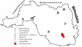
This diagram shows the position of this parish within the county of Glamorgan - click on this to see a full size diagram of the county
|
Plan of the parish of Pendoylan in the County of Glamorgan - on the People's Collection Wales site
Parish map (Kain/Oliver)
You can see maps centred on OS grid reference ST056775 (Lat/Lon: 51.488512, -3.361645), Pendoylan which are provided by:
- OpenStreetMap
- Google Maps
- StreetMap (Current Ordnance Survey maps)
- OpenStreetMap Cymru (Welsh counties only)
- Bing (was Multimap)
- Old Maps Online
- National Library of Scotland (Old Ordnance Survey maps)
- Vision of Britain (Click "Historical units & statistics" for administrative areas.)
- Magic (Geographic information) (Click + on map if it doesn't show)
- GeoHack (Links to on-line maps and location specific services.)
- All places within the same township/parish shown on an Openstreetmap map.
- Nearby townships/parishes shown on an Openstreetmap map.
- Nearby places shown on an Openstreetmap map.
Pendoylan War memorial - on the People's Collection Wales site
Places, villages, farms etc within Pendoylan as shown on the online parish map from the CD of Historic Parishes of England and Wales: an Electronic Map of Boundaries before 1850 with a Gazetteer and Metadata [computer file]. (Kain, R.J.P., Oliver, R.R.). (Extracted by Glenys Travis)
- Pendoylan [125]; - Bolgoed, Bryn Coch, Bryn, Bryn-helygan, Cae'r wigan, Cefn-llys, Clawdd-coch, Coed Leyshon, Dyffryn-bach, Dyffryn-lloff, Ffynnon Deilo, Hensol Castle, Hensol Fm, Hensol Park, Lillypot Fm, Llanerch, Llwyn rhyddid, Maesaraul (Maes-yr-haul in 1885), Mountain Lodge, Plwcca Dafydd, Pysgodlyn Mawr, Ty fry House, Ty Mawr, Tynewydd, Ty'n-y-cae, Tyn-y-pwll, Vicarage, Warren Fm
The Population of Pendoylan was as follows, and a more detailed breakdown is available.
| 1841 - 401 | 1851 - 363 | 1861 - 380 | 1871 - 452 | 1881 - 393 | 1891 - 352 |
Details of extant records on Archives Network Wales for the following;
- Pendoylan Civil Parish records "Records of the Pendoylan Parish Council/Community Council comprising tithe plan and apportionment, 1847; assistant overseers rate books, 1900-1926; assistant overseers receipt and payment book, 1923-1927; poor rate book, 1871; minutes books, 1894-1980; Pendoylan War Memorial Hall Management Committee minutes books, 1926-1970"