
Hide
Penmaen
hide
Hide
hide
Hide
hide
Hide
Hide
"PEN MAEN, in the Cwmwd of Gwyr, Cantref of Eginog (now called the Hundred of Swansea), County of GLAMORGAN, South Wales: a discharged Rectory valued in the King's Books at £4..10..0: Patron, The Lord Chancellor: Church dedicated to St. John the Baptist. The Resident Population of this Parish, in 1801, (including the little Hamlet of Paviland) was 131. The Money raised by the Parish Rates, in 1803, was £7..7..9. It is 9 m. W. S. W. from Swansea. This Parish contains about 450 acres of inclosed Land, and about 300 acres uninclosed. The Hamlet of Paviland is six miles to the Westward of Pen Maen: and from which, one of the Church wardens and Overseers of the Poor for the Parish are chosen. Below the Church, on the Sea shore, are some very grand Rocks, particularly one called The Great Tor, which runs up to a great height, terminating in a sharp point: at 1ow water spring tides, there is a Passage under this Rock, which allows of a pleasant ride over Oxwich Sands and Pen Arth Burrows to Swansea, and is a saving of between two and three miles. The Rocks form the Eastern side of Oxwich Bay. About a quarter of a mile further is a small Pill or Rivulet, running up into Nicholaston Marsh, which divides one part of this Parish, and Oxwich, from that of Nicholaston. According to the Diocesan Report, in 1809, the yearly value of this Benefice, arising from Augmentation, Tythes, Glebe, and Surplice Fees, was £143..10..0." From: A Topographical Dictionary of The Dominion of Wales by Nicholas Carlisle, London, 1811.
"PENMAEN (PEN-MAEN), a parish in the hundred of SWANSEA, county of GLAMORGAN, SOUTH WALES, 9 miles (W. S. W.) from Swansea, containing 137 inhabitants. The name of this place, signifying literally "the head of the rock," is derived from its situation at the extremity of a ridge of rocks forming the eastern side of Oxwich bay, in the Bristol channel. The parish comprises but a small tract of land, of which little more than half is enclosed and cultivated. The rocks on the coast below the church rise with majestic grandeur from the shore, and have a strikingly imposing appearance : one of them, called the Tor, after attaining a considerable elevation, terminates nearly in a point. At low water there is a pleasant ride to Oystermouth and Swansea, over the Oxwich sands, by which from two to three miles are saved in the distance. About six miles to the west of the church is the small hamlet of Paviland, belonging to this parish, from which place one of its churchwardens and one of its overseers are invariably chosen. The living is a discharged rectory, in the archdeaconry of Carmarthen, and diocese of St. David's, rated in the king's books at £4. 10., endowed with £200 private benefaction, and £200 royal bounty, and in the patronage of the King, as Prince of Wales. In the hamlet of Paviland there is a small meeting-house, built by Lady Barham. It is in contemplation to erect a school-house, and to establish a school here, for the gratuitous instruction of poor children, in connexion with the National Society in London. The average annual expenditure for the support of the poor amounts to £48. 14." ( A Topographical Dictionary of Wales by Samuel Lewis 1833)
Hide
Here is a substantial reading list of books which relate to Glamorgan, either county or parish.
The Glamorgan Family History Society have produced a set of microfiche containing Monumental Inscriptions for the following burial grounds :-
- Parish Church of St. John the Baptist
| St Mary's Chapel, Penmaen |
| Chapel, Penmaen |
Chapels Database - a list of all known non-conformist chapels or other non-Anglican religions in the parish
For full and up-to-date details of their holdings see the sites of Glamorgan Record Office and/or West Glamorgan Archives
See Bap/Mar/Bur data on FreeReg
The church is dedicated to St. John the Baptist, is in the Benefice of Oxwich with Penmaen with Nicholaston, and diocese of Swansea and Brecon. Details of the present incumbent of this benefice can be found at the Church in Wales website. The church can be located at grid reference SS532887.
| Anglican Parish Registers Held at the Glamorgan Record Office, Cardiff | ||||
| Baptisms | Marriages | Burials | Banns | Bishops Transcripts |
| 1765-1985 | 1765-1812, 1814-1970 | 1768-1810, 1815-1985 | - | 1686-1687, 1690, 1696-1697, 1700-1701, 1704, 1707-1708, 1710, 1712-1713, 1716, 1730-1733, 1735, 1737-1756, 1758-1759, 1761-1800, 1802, 1804-1870, 1873-1875, 1880, 1885, 1887, 1891-1902 (All held at the National Library of Wales, Aberystwyth) |
Details of extant records on Archives Network Wales for the following;
- Penmaen Ecclesiastical Parish Records "Registers (including service and banns registers) 1765-1985; Churchwardens' accounts 1820-1962; papers relating to church property and fabric 1822-1972; PCC minutes and related papers 1920-1960; Vestry minutes 1838-1895; miscellaneous 1894- 1939"
The following Religious Institutions are covered in the Mormon International Genealogical Index (IGI) :-
- Penmaen, St. John the Baptist - Christenings (BT's), 1813-1875
Various landscapes- on the People's Collection Wales site
Transcript of complete name listing for the Gower parishes, from Slaters Directory for 1880.
The transcription of the section for Penmaen from The National Gazetteer (1868) provided by Colin Hinson.
- Ask for a calculation of the distance from Penmaen to another place.
Some of the hamlets, towns and villages within this parish
- Pilton Green (in detached part of the parish)
Description and image of Penmaen Castle at www.castlewales.com by Jeff Thomas
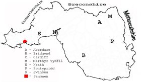
This diagram shows the position of this parish within the county of Glamorgan - click on this to see a full size diagram of the county
|
Map of the parish of Penmaen, Glamorganshire - on the People's Collection Wales site
Parish map (Kain/Oliver)
You can see maps centred on OS grid reference SS491876 (Lat/Lon: 51.576326, -4.112652), Penmaen which are provided by:
- OpenStreetMap
- Google Maps
- StreetMap (Current Ordnance Survey maps)
- OpenStreetMap Cymru (Welsh counties only)
- Bing (was Multimap)
- Old Maps Online
- National Library of Scotland (Old Ordnance Survey maps)
- Vision of Britain (Click "Historical units & statistics" for administrative areas.)
- Magic (Geographic information) (Click + on map if it doesn't show)
- GeoHack (Links to on-line maps and location specific services.)
- All places within the same township/parish shown on an Openstreetmap map.
- Nearby townships/parishes shown on an Openstreetmap map.
- Nearby places shown on an Openstreetmap map.
Places, villages, farms etc within Penmaen parish as shown on the online parish map from the CD of Historic Parishes of England and Wales: an Electronic Map of Boundaries before 1850 with a Gazetteer and Metadata [computer file]. (Kain, R.J.P., Oliver, R.R.). (Extracted by Mary Greatorex)
- Penmaen (41): Beacons, Church, Great Tor, Longoak, Parc Le Breos, Park Wood, Parkmill, Penard Pill, Penmaen Burrows, Tumulus, Workhouse.
- Penmaen (41) detached: Blackhole Gut, Common Cliff, Foxhole Slade, Paviland, Pilton Green
The People's Collection Wales site has material for this parish, use the onsite search box
The Population of Penmaen was as follows, and a more detailed breakdown is available.
| 1841 - 149 | 1851 - 114 | 1861 - 123 | 1871 - 161 | 1881 - 121 | 1891 - 138 |
Details of extant records on Archives Network Wales for the following;
- Penmaen Tithe Plan and Apportionment "Tithe plan and apportionment for Penmaen 1844-1846; copy of tithe plan and apportionment, [late 20th century]."
Details of extant records on Archives Network Wales for the following;
- Penmaen National School "....was closed in 1933. National Schools were originally established by the National Society to teach an Anglican education. The school was reopened temporarily during the Second World War to cater for the increased number of pupils at Parkmill School, caused by the arrival of evacuees from London."
"Log books of Penmaen School, 1875-1944"