
Hide
St Brides Major
hide
Hide
hide
Hide
hide
Hide
Hide
"ST. BRIDE'S MAJOR, in the Cwmwd of Maenor Glynn Ogwr, Cantref of Cron Nedd (now called the Hundred of Ogmore), County of GLAMORGAN, South Wales: a discharged Vicarage, with the Curacy of Wick, valued in the King's Books at £9..16..5 1/2: Patron, Richard T. Turbervill, Esq. The Resident Population of this Parish, in 1801 (consisting of the Hamlets of the St. Bride's, Llamphy, and Southern-Down), was 682. The Money raised by the Parish Rates, in 1803, was £352..11..0 3/4, at 2s. 2d. in the pound. It is 4m. S. b. E. from Bridgend. This Parish contains 3000 acres of inclosed and cultivated Land, and about 1500 acres of open Downs. Here is an immense Spring, which issues out of a Rock at the extremity of the Parish, and which is esteemed equal to the Water of the Hot Wells for keeping. It is situate near the Bristol Channel. ROBERT THOMAS, the Poet, was a Native of this place: and flourished from about the year 1700 to 1750."
From: A Topographical Dictionary of The Dominion of Wales by Nicholas Carlisle, London, 1811.
Hide
Here is a substantial reading list of books which relate to Glamorgan, either county or parish.
An index to the book St. Brides Major, Southerndown & Ogmore by Sea, A chronicle of a parish in the Vale of Glamorgan, by Stanley W. Bevan [1980], has been provided by Pat Grimes
The Glamorgan Family History Society have produced a set of microfiche containing Monumental Inscriptions for the following burial grounds :-
- Parish Church of St. Bridget
| Betharran Independent Chapel, Brynmenyn |
Chapels Database - a list of all known non-conformist chapels or other non-Anglican religions in the parish
See Welsh Chapels and Churches for a photograph of St Bridget's Church ST. BRIDE MAJOR, St. Bridget
For full and up-to-date details of their holdings see the sites of Glamorgan Record Office and/or West Glamorgan Archives
See Bap/Mar/Bur data on FreeReg
The church is dedicated to St. Bridget, is in the Benefice of Ewenny with St. Brides Major, and Diocese of Llandaff. Details of the present incumbent of this benefice can be found at the Church in Wales website. The church can be located at grid reference SS894750.
A transcription of the registers is available from the Glamorgan Family History Society for the years: Baptisms, 1721-1901, Marriages, 1721-1837, Burials, 1721-1901.
| Anglican Parish Registers Held at the Glamorgan Record Office, Cardiff | ||||
| Baptisms | Marriages | Burials | Banns | Bishops Transcripts |
| 1723-1992 | 1723-1807, 1813-1962 | 1723-1955 | - | 1721, 1723-1837 |
Modern Parishes & Chapels of Ease :-
| Non Conformist Registers Held at the National Library of Wales, Aberystwyth | ||||
| Chapel | Baptisms | Marriages | Burials | OS Map Ref |
| Bryn Sion, Calvinistic Methodist | - | 1976-1986 | - | SS 89627497 |
The following Religious Institutions are covered in the Mormon International Genealogical Index (IGI) :-
- St. Brides Major, St. Bridget - Christenings (BT's), 1813-1864
St Brides Major - on Wikipedia
Conservation areas within the Vale of Glamorgan. See St Brides Major - "Conservation areas are areas of special architectural or historic interest, the character or appearance of which it is desirable to preserve or enhance"
Various landscapes - on the People's Collection Wales site
Transcript of name listing for Bridgend and district, from Slaters Directory for 1880.
The transcription of the section for St Brides Major from The National Gazetteer (1868) provided by Colin Hinson.
Description of parish from A Topographical Dictionary of Wales (1833) by Samuel Lewis
- Ask for a calculation of the distance from St Brides Major to another place.
Some of the hamlets, towns and villages within this parish
|
|
Aerial photograph of Dunraven Iron Age hillfort and remains of Dunraven Castle, 1992 - on the People's Collection Wales site
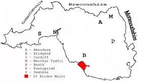
This diagram shows the position of this parish within the county of Glamorgan - click on this to see a full size diagram of the county
|
Map of the parish of St Brides Major, Glamorganshire - on the People's Collection Wales site
Parish map (Kain/Oliver)
You can see maps centred on OS grid reference SS896747 (Lat/Lon: 51.460474, -3.590501), St Brides Major which are provided by:
- OpenStreetMap
- Google Maps
- StreetMap (Current Ordnance Survey maps)
- OpenStreetMap Cymru (Welsh counties only)
- Bing (was Multimap)
- Old Maps Online
- National Library of Scotland (Old Ordnance Survey maps)
- Vision of Britain (Click "Historical units & statistics" for administrative areas.)
- Magic (Geographic information) (Click + on map if it doesn't show)
- GeoHack (Links to on-line maps and location specific services.)
- All places within the same township/parish shown on an Openstreetmap map.
- Nearby townships/parishes shown on an Openstreetmap map.
- Nearby places shown on an Openstreetmap map.
Places, villages, farms etc within St Brides Major as shown on the online parish map from the CD of Historic Parishes of England and Wales: an Electronic Map of Boundaries before 1850 with a Gazetteer and Metadata [computer file]. (Kain, R.J.P., Oliver, R.R.). (Extracted by Gareth Hicks)
- Southerndown (115); Black Rocks; Caves; Glan-y-mor; Sealawn Fm.; Southern-down (village).
- St Brides Major (114); Beacons Down; Blackhall; Bryn Awel; Castle upon Alun; Clemenston Brook; Craig-yr-eos; Croes Antony; Cwm Alun; Cwm Mawr; Dancing Stones; Deer Park; Dunraven Castle; Durfol; Flemings Down; Golf Links; Groes; Groes Gwta; Heol y Milwyr; Heol-y-mynydd; Heol y Slough; Kingshall; Little Norton; Mount Pleasant; Norton Hall; Ogmore (village); Ogmore Castle (in ruins); Ogmore Down; Ogmore (Ogwr) River; Old Castle Down; Old Castle-upon-Alun; Pant; Pant Mari Flanders; Pant St Brides; Pant-y-groes Lodge; Pen-ucha'r-dre; Pen-y-lan; Pitcot; Pitcot Fm.; Pont Alun; Pumping Sta.; Round Cott.; Sealands; Sea Mouth; Slade; Southerndown Rd. Sta.; St Brides Major (village); Sutton; Sutton Quarries; The Flats; Traeth Bach; Trywyn y Witch; Tychau Rhiw-clai; Ty-maen; Ty'n-y-caeau; Vicarage; Whitmore Stairs
- Llampha (113); Llampha; Pentre-hwnt; Tai'r-croes; Tair Croes Down;
The Population of St Brides Major was as follows, and a more detailed breakdown is available.
| 1841 - 914 | 1851 - 807 | 1861 - 826 | 1871 - 766 | 1881 - 674 | 1891 - 621 |