
Hide
Tythegston
hide
Hide
hide
Hide
hide
Hide
Hide
"TYTHEGSTON, in the Cwmwd of Tir yr Hwndrwd, Cantref of Cron Nedd (now called the Hundred of Newcastle), County of GLAMORGAN, South Wales: a Curacy, not in charge, consolidated with the Vicarage of Newcastle: Patron, The King: Church dedicated to St. Tudwg. The Resident Population of this Parish, in 1801, (consisting of the Higher and Lower Divisions) was 283. The Money raised by the Parish Rates, in 1803, was, £107..19..8 1/4. It is 3 m. W. b. S. from Bridgend. This Parish contains about 700 acres of Land; of which, nearly 100 acres are uninclosed. On the Estate of HENRY KNIGHT, Esq., are the remains of a Cromlech." From: A Topographical Dictionary of The Dominion of Wales by Nicholas Carlisle, London, 1811.
"TYTHEGSTON (LLAN-DUDWG), a parish, comprising the Upper and Lower divisions, each of which separately maintains its own poor, in the hundred of NEWCASTLE, county of GLAMORGAN, SOUTH WALES, 3 1/2 miles (w.) from Bridgend, and containing 404 inhabitants, of which number, 302 are in the Upper, and 102 in the Lower, division. The present name of this place is only a modification of its ancient Welsh name Llan Dudwg, signifying " Dudwg's town," and originally derived from the dedication of its church to St. Dudwg, or Tudwg, one of the disciples of Cenydd, who flourished about the middle of the sixth century. The parish is but of small extent, but contains some good arable and pasture land : the upper division abounds with iron-ore, coal, and clay for making bricks, of which considerable quantities are procured, and, by means of a rail-road communicating with the little harbour of Porthcawl, are shipped off to the neighbouring coasts. The living is annexed to the vicarage of Newcastle, in the archdeaconry and diocese of Llandaf. The church is a small ancient edifice, not distinguished by any architectural details. A school for the gratuitous instruction of poor children has been established in the Lower hamlet, and is supported by subscription. Catherine Lougher, and Thomas Leyson, in 1730, bequeathed each a small portion of land to the poor of the parish. The average annual expenditure for the support of the poor of the whole parish amounts to £130. 19., of which sum, £76.2. is assessed on the Higher, and £54. 17. on the Lower, division." ( A Topographical Dictionary of Wales by Samuel Lewis 1833
Hide
Here is a substantial reading list of books which relate to Glamorgan, either county or parish.
The Glamorgan Family History Society have produced a set of microfiche containing Monumental Inscriptions for the following burial grounds :-
- Parish Church of St. Tydwg
| Calvary English Baptist Chapel (Cefncribwr), Cefn Cribwr |
| Nebo Welsh Baptist Chapel, Cefncribwr |
| Siloam Welsh Independent Chapel, Cefncribwr |
| Wesleyan Methodist Chapel, Cefn Cribwr |
Chapels Database - a list of all known non-conformist chapels or other non-Anglican religions in the parish
See Welsh Chapels and Churches for photographs of various churches/chapels in this parish
For full and up-to-date details of their holdings see the sites of Glamorgan Record Office and/or West Glamorgan Archives
See Bap/Mar/Bur data on FreeReg
The church is dedicated to St. Tydwg, is in the Benefice of Laleston with Tythegston and Merthyr Mawr, and is in the diocese of Llandaff. Details of the present incumbent of this benefice can be found at the Church in Wales website. Church is no longer in use.. The church can be located at grid reference SS858788.
A transcription of the registers is available from the Glamorgan Family History Society for the years: Baptisms, 1721-1901, Marriages, 1723-1837, Burials, 1721-1901.
| Anglican Parish Registers Held at the Glamorgan Record Office, Cardiff | ||||
| Baptisms | Marriages | Burials | Banns | Bishops Transcripts |
| 1758-1987 | 1837-1965 | 1766-1987 | - | 1721, 1723-1835, 1837 |
Details of extant records on Archives Network Wales for the following;
- Tythegston Ecclesiastical Parish records "........... including registers of baptisms, 1758-1987; marriages, 1813-1965; burials, 1766-1987; banns, 1824-1831; churchwardens records, 1932-1940; vestry minutes, 1877-1967"
Modern Parishes & Chapels of Ease :-
The following Religious Institutions are covered in the Mormon International Genealogical Index (IGI) :-
- Tythegston, St. Tydwg - Christenings (BT's), 1818-1875
A view of Tythegston village near Porthcawl. - on the People's Collection Wales site
Transcript of name listing for Bridgend and district, from Slaters Directory for 1880.
The transcription of the section for Tythegston from The National Gazetteer (1868) provided by Colin Hinson.
- Ask for a calculation of the distance from Tythegston to another place.
Some of the hamlets, towns and villages within this parish
|
|
Details of extant records on Archives Network Wales for the following;
- Knight, R. L., of Tythegston Court, deeds and papers 1450-1943 "Francis Knight, alderman and twice mayor of the city of Bristol, was granted an estate at Congresbury, Somerset, by Queen Elizabeth I. Francis's descendant, Robert Knight, married Cecil Turberville of Sutton, granddaughter and heiress of Richard Lougher of Tythegston, Glamorgan, in 1708. The estate of Tythegston and Lougher manor therefore passed to the Knight family of Bristol. Robert's grandson, Henry Knight (d. 1772) purchased Pembroke manor (named after the Herberts, earls of Pembroke) in 1771. Henry's eldest son, Colonel Henry Knight (d. 1825), died without issue. ...................................."
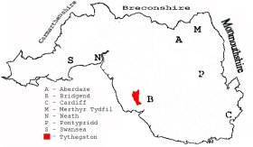
This diagram shows the position of this parish within the county of Glamorgan - click on this to see a full size diagram of the county
|
A map of the parish of Tythegstone in the County of Glamorgan - on the People's Collection Wales site
Parish map (Kain/Oliver)
You can see maps centred on OS grid reference SS853814 (Lat/Lon: 51.496569, -3.646502), Tythegston which are provided by:
- OpenStreetMap
- Google Maps
- StreetMap (Current Ordnance Survey maps)
- OpenStreetMap Cymru (Welsh counties only)
- Bing (was Multimap)
- Old Maps Online
- National Library of Scotland (Old Ordnance Survey maps)
- Vision of Britain (Click "Historical units & statistics" for administrative areas.)
- Magic (Geographic information) (Click + on map if it doesn't show)
- GeoHack (Links to on-line maps and location specific services.)
- All places within the same township/parish shown on an Openstreetmap map.
- Nearby townships/parishes shown on an Openstreetmap map.
- Nearby places shown on an Openstreetmap map.
Places, villages, farms etc within Tythegston as shown on the online parish map from the CD of Historic Parishes of England and Wales: an Electronic Map of Boundaries before 1850 with a Gazetteer and Metadata [computer file]. (Kain, R.J.P., Oliver, R.R.). (Extracted by Gareth Hicks)
- Tythegston Lower (96); Clement; Mynydd Herbert; Pwll-y-mer; Redhill; The Beacons; Twmpath y Ddaiar; Ty-erfin; Tythegston; Tythegston Court; Witland.
- Tythegston Higher (97); Brombel; Cae-gof; Camp (2); Cefn Cribwr; Ffald; Ffynnon-y-maen; GWR; Horgrove; Kenfig Hill; New Pit; Parc-isaf; Parc-uchaf; Quarry(2); Stormy; Stormy Down; Tranch; Ty-fry; Ty'n-y-caeau;
The Population of Tythegston was as follows, and a more detailed breakdown is available.
| 1841 - 794 | 1851 - 1,152 | 1861 - 1,678 | 1871 - 1,490 | 1881 - 1,638 | 1891 - 1,578 |
Details of extant records on Archives Network Wales for the following;
- Tythegston Civil Parish records " .........comprising road accounts, 1768-1800; parochial committee minutes book, 1911-1931; parish council minutes books, 1925-1974; Tythegston higher Community Council minutes book, 1974-1984; parish council receipt and payment books, 1935-1974; parish council minutes and accounts relating to the festival of Wales and the investitute of the Prince of Wales, 1958-1969; records relating to Cefn Cribbwr Welfare and Public Hall, 1923-1971; annotated ordnance survey, 1949; copy of tithe plan and apportionment, c1840 [copied 1980]; Cefn Cribbwr: Chronicle of a Village1980"
Details of extant records on Archives Network Wales for the following;
- Pyle, Kenfig and Tythegston Higher School Board records ".......... comprising of minute books, 1875-1903; ledgers, 1894-1903; rough ledger, 1901-1903"