
Hide
Burgh on Bain
hide
Hide
hide
Hide
hide
Hide
Hide
hide
Hide
Hide
The Library at Louth will prove useful in your research.
J. THOMAS has a phtograph of St. Helen's Churchyard on Geo-graph, taken in May, 2020.
- The parish was in the Binbrook sub-district of the Louth Registration District.
- The North Lincolnshire Library holds a copy of the parish census returns for 1841 and 1881.
- Check our Census Resource page for county-wide resources.
- The table below gives census piece numbers, where known:
| Census Year | Piece No. |
|---|---|
| 1841 | H.O. 107 / 629 |
| 1851 | H.O. 107 / 2112 |
| 1861 | R.G. 9 / 2384 |
| 1871 | R.G. 10 / 3406 |
| 1891 | R.G. 12 / 2609 |
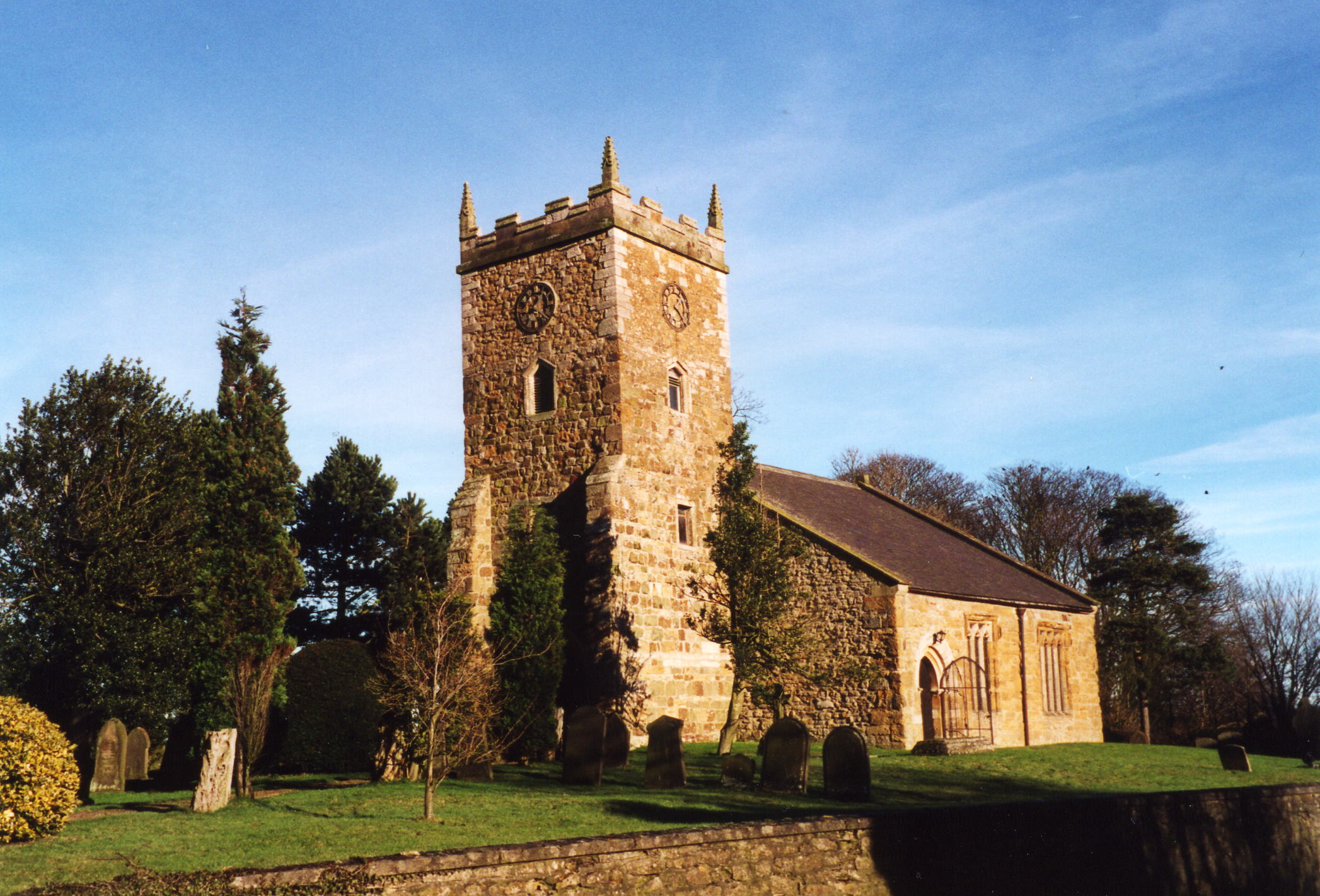
- The Anglican parish church is dedicated to Saint Helen.
- The church is a small stone structure, containing monuments to the PINDAR and LISTER families.
- The church restored in 1872 by Captain J. W. FOX.
- The church seats about 120.
- The church is a Grade II listed building with British Heritage.
- A photograph of St. Helen's Church exists at the Wendy PARKINSON English Church Photographs site.
- Here is a photo of the church, taken by Ron COLE (who retains the copyright):
- Parish register entries start in 1575, but Bishop's transcripts go back to 1561.
- The National Burial Index (NBI) lists 309 entries (1813-2000) for the parish church.
- The LFHS has published several marriage and burial indexes for the Horncastle Deanery to make your search easier. Around 1900, the parish was part of the Louthesk Deanery.
- Check our Church Records page for county-wide resources.
- The parish was in the Binbrook sub-district of the Louth Registration District.
- Check our Civil Registration page for sources and background on Civil Registration which began in July, 1837.
Burgh on Bain is a village and a parish on the River Bain, seven miles west of Louth and 19 miles northeast of Lincoln. The parish covered about 1,870 acres of the Wold Hills in 1842 and includes the hamlet of Girsby, just north of the village of Burgh on Bain. By 1900, the parish boundaries had shrunk the acreage to about 1,600 acres
If you are planning a visit:
- By car, take the A157 between Wragby and Louth. It passes through the centre of Burgh on Bain, just east of the B1225 trunk road.
- J. THOMAS has a photograph of the Village Sign on Geo-graph, taken in May, 2020.
- See our touring page for visitor services.
- Ask for a calculation of the distance from Burgh on Bain to another place.
- The Burgh on Bain Long Barrow is considered a neolithic period barrow.
- The parish also has a Round Barrow from the Bronze Age.
- In 1842, the sole landowner was the Rev. William FOX, lord of the manor.
- In 1872 and 1882, the sole landowner was Captain John Wilson FOX, lord of the manor.
- In 1900 and 1913, the sole landowner was John St. Vigor FOX, lord of the manor.
- Girsby Hall, north of the village of Burgh on Bain, was the residence of the Rev. William FOX in 1842. It had long been the seat of the LISTER family, and the PINDAR family before that.
- See our Maps page for additional resources.
You can see maps centred on OS grid reference TF223864 (Lat/Lon: 53.360336, -0.16372), Burgh on Bain which are provided by:
- OpenStreetMap
- Google Maps
- StreetMap (Current Ordnance Survey maps)
- Bing (was Multimap)
- Old Maps Online
- National Library of Scotland (Old Ordnance Survey maps)
- Vision of Britain (Click "Historical units & statistics" for administrative areas.)
- English Jurisdictions in 1851 (Unfortunately the LDS have removed the facility to enable us to specify a starting location, you will need to search yourself on their map.)
- Magic (Geographic information) (Click + on map if it doesn't show)
- GeoHack (Links to on-line maps and location specific services.)
- All places within the same township/parish shown on an Openstreetmap map.
- Nearby townships/parishes shown on an Openstreetmap map.
- Nearby places shown on an Openstreetmap map.
- Kate NICOL has a photograph of the Crimean War Memorial for George BARNES on Geo-graph, taken in October, 2009.
- There is one WWII military grave in St. Helen's churchyard. It is for Lister Roderick GOULSBRA of the Royal Air Force Volunteer Reserve who died on 26 March 1943 at age 29.
- The origin of the name is the Old English burh for "fortification." The second part of the name comes from its loction on the River Bain, added because Burgh (often rendered as Brough) is a common name throught England. Variations of the on portion appear as upon, etc.
A. D. Mills, "A Dictionary of English Place-Names," Oxford University Press, 1991.
- White's 1842 Directory lists the following names in the parish: Rev. Charles BERNAL, Samuel BROWN, Thos. EYRE, William FOX, Thos. HILL, Robert KEMP, Robert Fell PORKESS, John TIMM, Joseph WAITE, John WALKER, Thomas WALLIS and William WALLIS.
- White's 1872 Directory lists the following names in the parish: Samuel BROWN, Capt. John Wilson FOX, Thomas HILL, Mrs. Susan KEMP, William MACHAM, Rev. Thomas Staples PEPPER, William RICHARDSON, Miss SPIVEY, Joseph THARRATT, John WALKER, George WALLIS, Joseph WALLIS and Thomas WALLIS.
- White's 1882 Directory lists the following names in the parish: George BIRD, George BROWN, Samuel BROWN, Capt. John W. FOX, Albert William HILL, Henry KEMP, Robert KEMP, William KIRK, William MACHAM, William PORTAS, Rev. William PRINCE, Miss Helen Mary RAINES, Simon ROBINSON, Joseph THARRATT, John WALKER, William WALKER, George WALLIS, George WALLIS Jnr. and Joseph WALLIS.
- Kelly's 1900 Directory lists the following names in the parish: George BIRD, George BROWN, Samuel BROWN, Thomas CRISP, Miss June DAWSON, George ENGLAND, John St. Vigor FOX, Henry KEMP, Robert KEMP, Rev. Herbert POOLEY, Edward Preston RAWNSLEY, Newcome SMITHSON, Joseph THARRATT, John WALKER, William WALKER, Thomas WALLIS and Benjamin WEBSTER.
- Kelly's 1913 Directory lists the following names in the parish: William Henry BROWN, Thomas CRISP, Mrs. Fanny ENGLAND, John St. Vigor FOX, Henry KEMP, Robert KEMP, Rev. Herbert POOLEY, Miss Mary E. RADFORD, John RUSSELL, Newcome SMITHSON, Joseph THARRATT, William WALKER, Benjamin WEBSTER and William WHITWORTH.
- This place was an ancient parish in Lincolnshire and became a modern Civil Parish when those were established.
- The parish was in the ancient Wraggoe Wapentake in the East Lindsey district in the parts of Lindsey.
- For today's district governance, see the East Lindsey District Council.
- Bastardy cases would be heard in the Wragby petty session hearings on the first Thursday of every month.
- As a result of the 1834 Poor Law Amendment Act, the parish became part of the Louth Poor Law Union.
Year Inhabitants 1801 95 1811 173 1831 131 1841 155 1851 177 1871 210 1881 170 1891 154 1901 179 1911 176 1921 151
- The parish school was built in 1868 by J. W. FOX. In 1872 it had 42 children attending. The school was enlarged in 1894.
- Jonathan THACKER has a photograph of the old school on Geo-graph, taken in June, 2012.
- For more on researching school records, see our Schools Research page.