
Hide
New Sleaford
hide
Hide
hide
Hide
hide
Hide
Hide
Hide
The Library at Sleaford will prove useful in your research.
- Richard CROFT has a photograph of Late 19th century headstone on Geo-graph, taken in April, 2016.
- The Cemetery, on the east side of town, is behind the old Alvey School, and was brought into service in 1856 by the New Sleaford and Holdingham Burial Board.
- The parish was in the Sleaford sub-district of the Sleaford Registration District.
- Check our Census Resource page for county-wide resources.
- The table below gives census piece numbers, where known:
| Census Year | Piece No. |
|---|---|
| 1841 | H.O. 107 / 622 |
| 1851 | H.O. 107 / 2100 |
| 1861 | R.G. 9 / 2342 & 2343 |
| 1871 | R.G. 10 / 3349 & 3350 |
| 1881 | R.G. 11 / 3223 |
- Holdingham formerly had a chapel dedicated to the Virgin Mary, but it appears to have gone unused about 1650. No records are known.
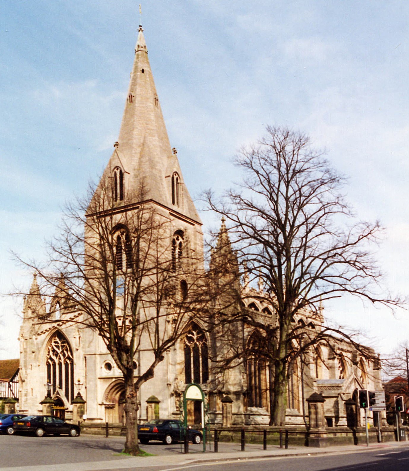
- The Anglican parish church is dedicated to St. Denys (some sources use "St. Denis").
- The church seats 1,088.
- The parish churchyard was closed to internments on 25 May, 1855.
- There is a photograph of St. Denys church on the Wendy PARKINGSON Church Photos web site.
- Here is a photograph of Saint Denys Church taken by Ron COLE (who retains the copyright):
- We have the beginnings of a Parish Register Extract in a text file. Your additions and corrections are welcome.
- The LFHS has published several marriage and burial indexes for the Lafford Deanery to make your search easier.
- Zion Chapel was built in 1776 by the Independents, then enlarged in 1819. A Wesleyan chapel was put up in 1823 to replace a smaller one which had opened in 1802. The primitive Methodists built their chapel in 1841.
- For information and assistance in researching these chapels, see our non-conformist religions page.
- Check our Church Records page for county-wide resources.
- The parish was in the Sleaford sub-district of the Sleaford Registration District.
- Check our Civil Registration page for sources and background on Civil Registration which began in July, 1837.
New Sleaford is both a parish and a part of the town of Sleaford. The parish lies 115 miles north of London and 14 miles ENE of Grantham. Leasingham parish lies to the north. The parish covers about 1,070 acres and includes the village of Holdingham.
If you are planning a visit:
- See our touring page for more sources.
- Ask for a calculation of the distance from New Sleaford to another place.
- The parish has a quarry from which durable white freestone, called Ancaster Stone, from which large quantities of stone were extracted.
- Market Day was held on Mondays.
- There were 5 annual cattle fairs, held on Plough Monday, Easter Monday, Whit Monday, August 12th and October 20th. There was also a cheese mart on October 1st.
- In 1636, Carre's Hospital was founed by Sir Robert CARRE of Old Sleaford.
- In 1792, the first Banking House in Sleaford was established (Messrs. PEACOCK, HANDLEYS and Co.).
- From 1829 through 1831 the entire township was paved and drained.
- In 1839, on October 1st, the township was first lighted with gas.
- In 1853, construction started on a railway from Boston through Swineshead to join the Great Northern line at Barkstone. The line betsween Grantham and Sleaford was opened in 1857.
- Debbie J. Has a photograph of the Workings of the Gogglesford Water Mill on Geo-graph, taken in September, 2013.
- See our "Maps" page for additional resources.
You can see maps centred on OS grid reference TF070467 (Lat/Lon: 53.007037, -0.406923), New Sleaford which are provided by:
- OpenStreetMap
- Google Maps
- StreetMap (Current Ordnance Survey maps)
- Bing (was Multimap)
- Old Maps Online
- National Library of Scotland (Old Ordnance Survey maps)
- Vision of Britain (Click "Historical units & statistics" for administrative areas.)
- English Jurisdictions in 1851 (Unfortunately the LDS have removed the facility to enable us to specify a starting location, you will need to search yourself on their map.)
- Magic (Geographic information) (Click + on map if it doesn't show)
- GeoHack (Links to on-line maps and location specific services.)
- All places within the same township/parish shown on an Openstreetmap map.
- Nearby townships/parishes shown on an Openstreetmap map.
- Nearby places shown on an Openstreetmap map.
- The name Sleaford is from the Old English esla+forde, meaning "ford over a muddy stream". In 852 the name first appears as Slioford. In the 1086 Domesday Book, the village is given as Eslaforde.
A. D. MILLS, "A Dictionary of English Place-Names," Oxford University Press, 1991.
- Holdingham was, in ancient times, rendered as "Haldingham". The name first appears in 1202.
- The distinction of New from Old Sleaford originated in the sixteenth century. New Sleaford began to increase in buildings and population, while Old Sleaford remained fairly unimproved.
- The parish was in the ancient Flaxwell Wapentake in the North Kesteven division of the county, in the parts of Kesteven.
- After the voting reforms of 1832, Sleaford became a polliing place for the members of parliament for the Southern Division of Lincolnshire.
- In 1908, the parish boundaries changed when part of New Sleaford was transferred to Old Sleaford.
- For today's district governance, contact the North Kesteven District Council.
- Bastardy cases would be heard in the Sleaford petty session hearings every Monday.
- In 1604, Robert CARRE of Aswarby provided a fund for the relief of the poor, aged and disabled people of New and Old Sleaford and Holdingham.
- In 1631, Robert CAMMOCK bequethed to New Sleaford funds to provide clothing for five poor people.
- In 1636, Sir Robert CARR(E) of Old Sleaford provided a fund for the relief of twelve poor men from this and nearby parishes.
- The Commons and open fields of the parish were enclosed in 1777 (some sources say 1794).
- After the Poor Law Amendment Act reforms of 1834, the parish became part of the Sleaford Poor Law Union.
Population totals are for the Township of New Sleaford.
Year Inhabitants 1801 1,483 1811 1,781 1821 2,094 1831 2,450 1841 3,181 1851 3,372 1871 3,592 1881 4,075 1891 3,597 1911 3,808
John BLAND provides a transcript of the will of Mary MARTIN of New Sleaford.
Ros DUNNING provides a transcript of the will of Tamberlain GWILLIM of New Sleaford.
- The Free Grammar School was endowed here in 1604 by Robert CARRE of Aswarby. The school eventually fell into decay and students were taught in the parish church until 1816, when the school was discontinued. It was rebuilt in 1834 in an Elizabethan style and classes continued. Although the school was free for classical learning, a fee of about two quineas was charged each year for any other branches of education.
- Mick LOBB has a photograph of Carre's Grammar School on Geo-graph, taken in 2009.
- In 1726, William ALVEY left an endowment for 20 poor boys and 20 poor girls to attend schooling. Alvey's Charity School was held in rented rooms up through 1841. In 1785, James HARRYMAN left the interest off of £100 to provide shoes and stockings for the children of this school.
- Richard CROFT has a photograph of Alvey School on Geo-graph, taken in October, 2011.
- Mick LOBB has a photograph of the William Alvey School from a slightly different angel on geo-graph, taken in December, 2009.
- For more on researching school records, see our Schools Research page.