
Hide
Sleaford
hide
Hide
hide
Hide
hide
Hide
Hide
"Sleaford (or New Sleaford), market town, par., and township with ry. sta., Lincolnshire, on river Slea, 17 miles SE. of Lincoln and 121 N. of London by rail - par., 3160 ac., pop. 4075; township, 1800 ac., pop. 3955; town (comprising the entire parishes of New Sleaford, Old Sleaford, and Quarrington), pop. ... Hide further information... 4965; P.O., T.O., 3 Banks, 1 newspaper. Market-day, Monday. Sleaford has a fine church of 1271, a grammar school of 1624, and a monumental cross of 1850. There is a considerable trade in agricultural produce. In the castle of the bishops of Lincoln at Sleaford King John sickened after his losses at the Wash"
John Bartholomew's Gazetteer of the British Isles 1887 Vision of Britain
Hide
The Sleaford Library, created on 27 Mar 2006, will provide guidance in your search for no fee, but will not do lookups for you. They normally open Monday thru Saturday at 9am, but closing hours vary. The Library has computers with Ancestry access, and it is affiliated with the Lincolnshire Library System, so Inter-Library Loans are possible.
- Sleaford Library
- Isaac Newton Centre
- 13 - 16 Market Place
- Sleaford, Lincs, NG34 7SR
- Tele: 01529 303394
- The parish churchyard was closed to internments on 25 May, 1855.
- The Cemetery, on the east side of town, is behind the old Alvey School, and was brought into service in 1856 and enlarged in 1882. It was under the control of the Urban District Council..
- The parish was in the Sleaford sub-district of the Sleaford Registration District.
- Check our Census Resource page for county-wide resources.
- The table below gives census piece numbers, where known:
| Census Year | Piece No. |
|---|---|
| 1841 | H.O. 107 / 615 |
| 1851 | H.O. 107 / 2100 & 2101 |
| 1861 | R.G. 9 / 2342 & 2343 |
| 1871 | R.G. 10 / 3350 |
| 1891 | R.G. 12 / 2578 & 2579 |
| St Denys, Sleaford, Church of England |
| St Giles, Sleaford, Church of England |
| Virgin Mary, Sleaford, Church of England |
| Boston Road, Sleaford, Baptist (General) |
| The Temple, Eastgate, Sleaford, Baptist (Particular) |
| Southgate, Sleaford, Congregationalist |
| Zion, Sleaford, Independent |
| Off Eastgate, Sleaford, Cemetery |
| Our Lady of Good Counsel, Sleaford, Roman Catholic |
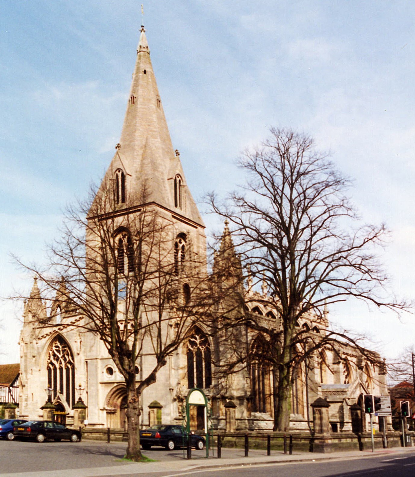
- The Anglican parish church is dedicated to Saint Denys (some sources use "St. Denis").
- The church seats 1,088.
- Shelly CLACK provides a list of names from the churchyard memorials. This is a Portable Document File.
- There is a photograph of the Anglican parish church on the Wendy PARKINSON Church Photos web site.
- Here is a photograph of Saint Denys Church taken by Ron COLE (who retains the copyright
li>
- The Anglican parish register dates from 1575.
- The Anglican parish churchwarden accounts exist for 1606 through 1627.
- Information on parish records can be found on the web pages for Old Sleaford and New Sleaford.
- The Lincolnshire FHS has a Loan Library service which has the parish registers on microfiche for Baptisms from 1653 to 1812 and Marriages from 1653 to 1812.
- The LFHS has published several marriage and burial indexes for the Lafford Deanery to make your search easier.
- The Catholic Church, dedicated to Our Lady of Good Counsel was erected in 1889. It can seat 300.
- Mcik LOBB has a photograph of Our Lady of Good Counsel on Geo-graph, taken in 2010.
- The Baptist chapel in Eastgate could seat 200 and was erected in 1881. A Wesleyan chapel was erected in Northgate in 1848. Southgate had a Congregational chapel built in 1868. The Primitive Methodists built a chapel in 1841 in Westgate.
- For information and assistance in researching these chapels, see our non-conformist religions page.
- Check our Church Records page for county-wide resources.
- The parish was in the Sleaford sub-district of the Sleaford Registration District.
- Check our Civil Registration page for sources and background on Civil Registration which began in July, 1837.
Sleaford is a principal town which covers portions of at least two parishes. The British would call it a conurbation, like Scunthorpe or several other towns in the county. Americans would more likely call it a place that had exceeded the original town limits, like San Francisco or New York. The two parishes that make up most of the town are Old Sleaford and New Sleaford. For many centuries, Old Sleaford was the more agrarian parish, while New Sleaford florished with construction and growth. Old Sleaford lies to the south and east of the Slea River and New Sleaford is on the northern and western banks of the river. The parish includes the hamlet of Holdingham.
The town is a crossroad place, 115 miles north of London and almost equi-distant between Newark in Nottinghamshire and Boston in Lincolnshire, with the Lincolnshire towns of Grantham 14 miles to the south-west and Bourne way off to the south, and the city of Lincoln 18 miles to the north. If you are planning a visit:
- A Roman Road used to run through the town from Tattershall to Ancaster. You will find the A153 trunk road an easier route by automobile. The A17 passes just north and the A15 just west of the town.
- See our touring page for more sources.
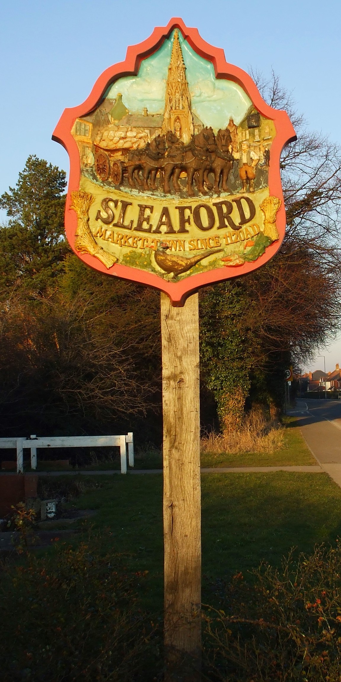
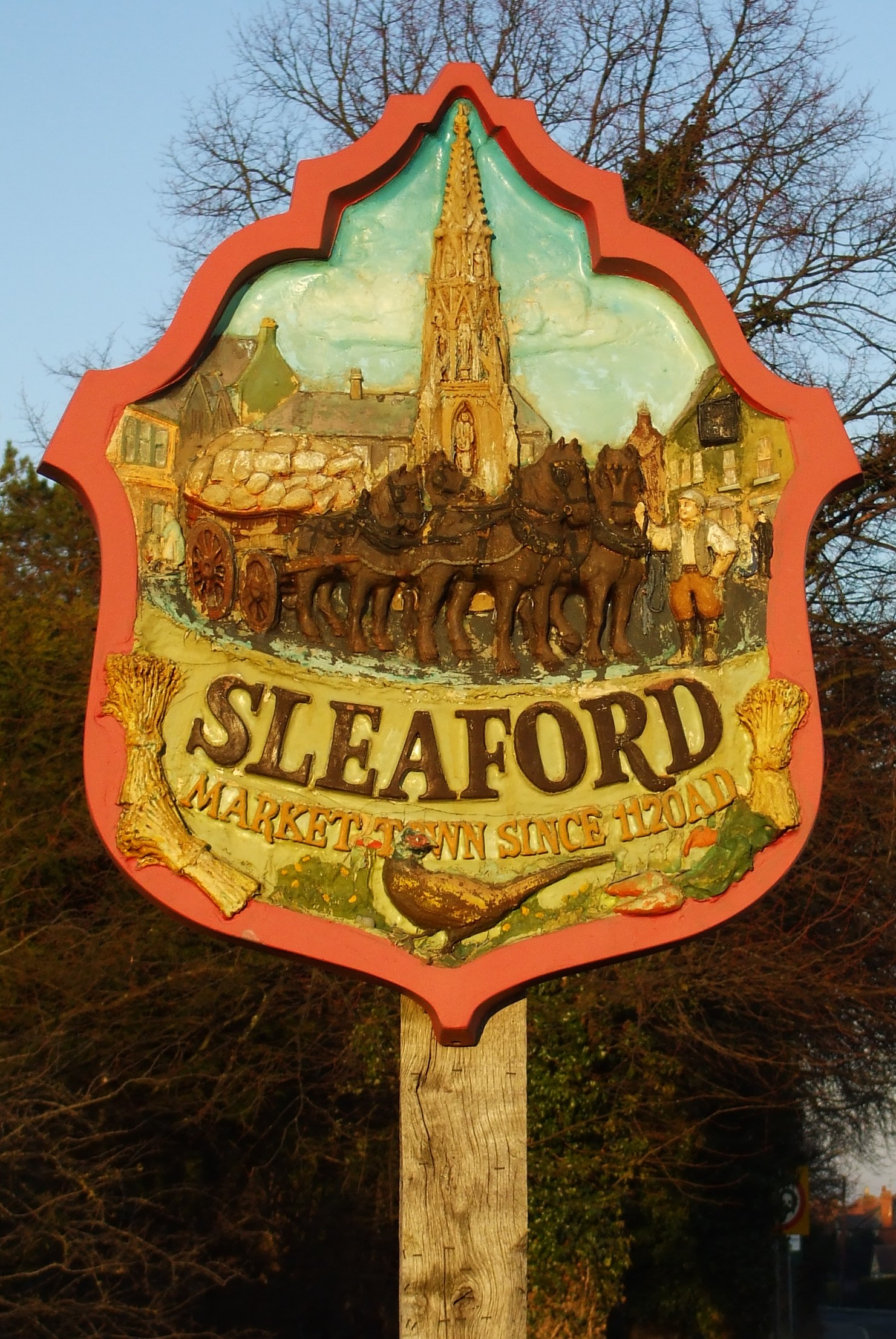
- Here are three photographs of the town sign, all taken in 2008 by Patricia McCRORY (who retains the copyright):
- Ask for a calculation of the distance from Sleaford to another place.
- Records indicate that Old and New Sleaford were separate parishes at the time of William the Conqueror. But some sources refer to Old Sleaford as simply a hamlet in the parish of Quarrington.
- You might want to find a copy of "Mid-Victorian Sleaford, 1851-1871," edited by Charles Ellis and printed in 1981, ISBN 08-6111-1028, 196 pages, paperback. I do not know if many names appear in the book.
- Sleaford was a market town and had a market day every Monday and a fair five times a year. It was a popular location because it sat at the juntion of six roads and five railway branches.
- About 1130, Bishop Alexander built a castle in a field just south-west of the town. (Sources vary as to where the castle was built.) In Queen Elizabeth's reign, it was pulled down.
- In 1792, the first banking house was established in Sleaford (Peacock, Handley & Company.
- A theater was built in town in 1824.
- From 1829 through 1831, the whole town had its streets repaved and widened, walls reflagstoned and portions of town drained properly. The major streets are called Gates, after the cardinal points, and intersect at right angles.
- In 1830, a new Town Hall (or Sessions House) was erected in the Market Place.
- The town was lighted with gas on 1 October, 1839.
- In 1845, a County Police Station and lock-up were erected in the Eastgate area of town.
- In 1857, the Corn Exchange was built on the Market Place. The Butter market occupied the basement.
- In 1857-58, when a railway line was being built south of the town, a large Anglo-Roman cemetery was discovered. Nigel THOMAS has a photograph of the railway station on Geo-graph, taken in 2000.
- The Great Northern Railway line provided direct transport to Boston and the East Coast. The Great Eastern railway served the town as well.
- For the steam-powered railway buff, Ben BROOKSBANK has a photograph of a 1948 A1 Pacific locomotive on Geo-graph, taken in September, 1954.
- In 1879, the Sleaford Water Compnay started pumping water from a spring to a resevoir on a hill about a mile from the town.
- Read about the Sleaford May Fair in 1882. The Fair is still celebrated, albeit on a smaller scale.
- An Urban District Council was formed under the "Local Government Act" of 1894, with 12 members to manage the town's future.
- Richard CROFT has a photograph of the now closed Marquis of Granby public house on Geo-graph, taken in February, 2009. The pub. dates from the 1700s and is now a Grade II structure with English Heritage
- See our Maps page for additional resources.
You can see maps centred on OS grid reference TF068457 (Lat/Lon: 52.998256, -0.40967), Sleaford which are provided by:
- OpenStreetMap
- Google Maps
- StreetMap (Current Ordnance Survey maps)
- Bing (was Multimap)
- Old Maps Online
- National Library of Scotland (Old Ordnance Survey maps)
- Vision of Britain (Click "Historical units & statistics" for administrative areas.)
- English Jurisdictions in 1851 (Unfortunately the LDS have removed the facility to enable us to specify a starting location, you will need to search yourself on their map.)
- Magic (Geographic information) (Click + on map if it doesn't show)
- GeoHack (Links to on-line maps and location specific services.)
- All places within the same township/parish shown on an Openstreetmap map.
- Nearby townships/parishes shown on an Openstreetmap map.
- Nearby places shown on an Openstreetmap map.
- In 1882: E Company of the Second Lincolnshire Rifle Volunteer Corps, numbering a little over 60 men, had a drill-shed in Southgate. Captain H. INGOLDBY, commanding; H. A. PEAKE, lieutenant; and Sergeant M. CLEARY, drill-instructor.
- Captain H. INGOLDBY we believe is Henry INGOLDBY, bank manager at Saving's Bank in 1881. He was 58, born Boston, married to Mary (also born Boston). H. A. PEAKE we believe is Henry Arthur PEAKE, secretary to the Water Company. He was 25, single, born New Sleaford. We have not found Sergeant M. CLEARY yet.
- In 1900: E Company of the Volunteer Battalion, Lincolnshire Regiment, had an armoury and orderly room at West Banks. Captain Rowland Sydney GOWARD, commanding; Robert Mancrieffe EARL, lieutenant; and Arthur C. HOWARD, second lieutenant.
- Archives for the Lincolnshire Rifle Volunteer Corps
- Sleaford adopted the HMS Sheldrake in 1942. She was built in 1936 as a Kingfisher Class Patrol Boat. A model of the ship was presented to the Town Council. In 1946 she was sold to the Palu Steam Navigation Company for commercial use.
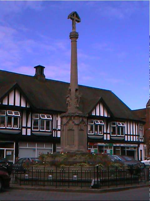
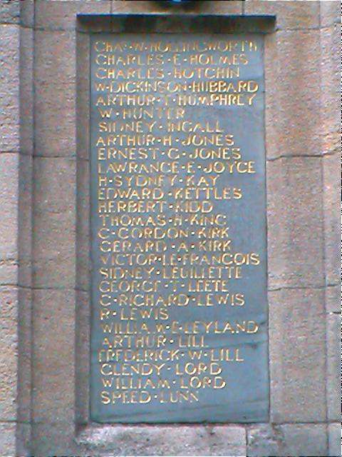
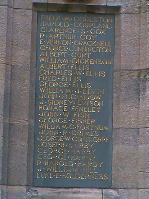
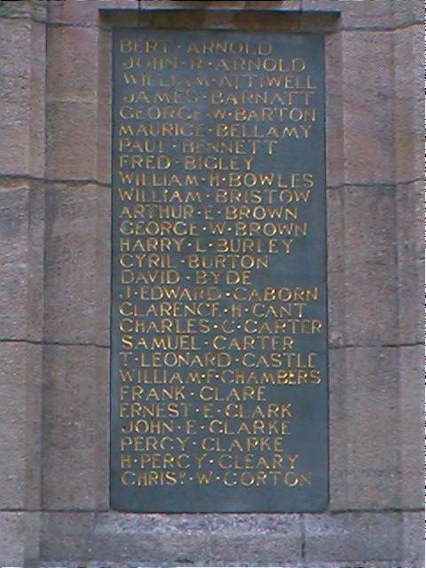
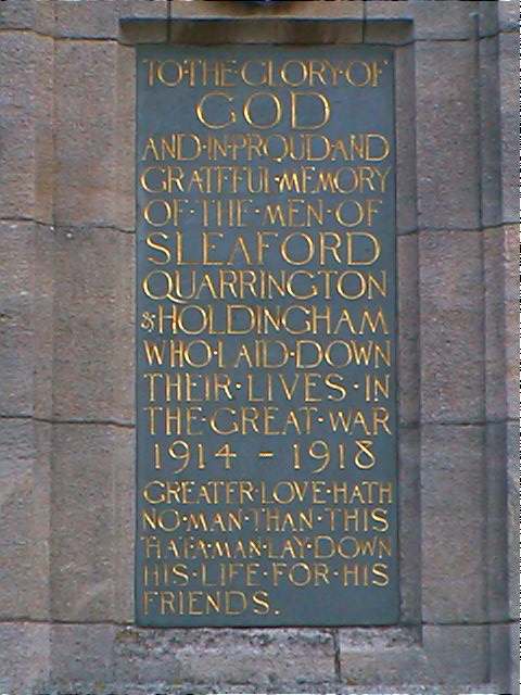
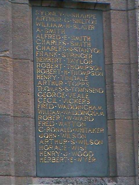
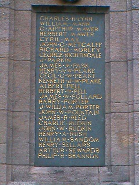
John Emerson, who retains the copyright, provides these photographs of the war memorial at Sleaford:
- The name first appears as "Slioford" in 852.
- "Sleaford" derives from the manor name Eslaforde, as listed in the 1086 Domesday Book. The River Slea passes through the center of town, on its way to join the River Witham.
- Click to see the text file: Bailey's British Merchant's and Trader's Useful Companion for 1784 list of names. [Mark in Barcelona]
- The Sleaford Gazette was established in 1854. In 1882 it was published weekly, on a Saturday, by Mr. Henry WATKINSON.
- Copies of the Sleaford Gazette and Standard for 1868 - 2002 (1960 missing) are at the Sleaford Library on 35mm film.
- The Sleaford Journal was established in 1879. In 1882 it was published weekly, on a Saturday, by Mr. William WALSOH.
- Copies of the Sleaford Journal for 1885 - 1929 are at the Sleaford Library on 35mm film.
- Please check our Newspapers page for more information.
- This place was an ancient parish in Lincoln county and became a modern Civil Parish when those were created.
- The town was in the ancient Flaxwell Wapentake in the North Kesteven district in the parts of Kesteven.
- You can contact the Sleaford Town Council for current political issues and actions. They will NOT do family history searches for you.
- For today's district governance, contact the North Kesteven District Council.
- Bastardy cases would be heard in the Sleaford petty session hearings every Monday.
- Information on Poor Law records can be found on the web pages for Old Sleaford and New Sleaford.
- The Common Lands were enclosed here in 1777.
- After the Poor Law Amendment Act reforms of 1834, the parish became the heart of the Sleaford Poor Law Union.
Population figures given below include workhouse staff and inmates.
Year Inhabitants 1801 ~1,596 1841 ~3,379 1881 3,955 1891 4,112 1901 4,508 1911 6,331
- Information on school records can be found on the web pages for Old Sleaford and New Sleaford.