
Hide
Waithe
hide
Hide
hide
Hide
hide
Hide
Hide
[Transcribed from The National Gazetteer of Great Britain and Ireland 1868]
by Colin Hinson ©2020
Hide
The Library at Louth will prove useful in your research.
David HITCHBORNE has a photograph of the Churchyard at St. Martin's on Geo-graph, taken in June, 2004.
| St Martin, Waithe, Church of England |
- The parish was in the Tetney sub-district of the Louth Registration District.
- Check our Census Resource page for county-wide resources.
- The table below gives census piece numbers, where known:
| Census Year | Piece No. |
|---|---|
| 1851 | H.O. 107 / 2112 |
| 1861 | R.G. 9 / 2387 |
| 1871 | R.G. 10 / 3410 |
| 1891 | R.G. 12 / 2611 |
| St Martin, Waithe, Church of England |
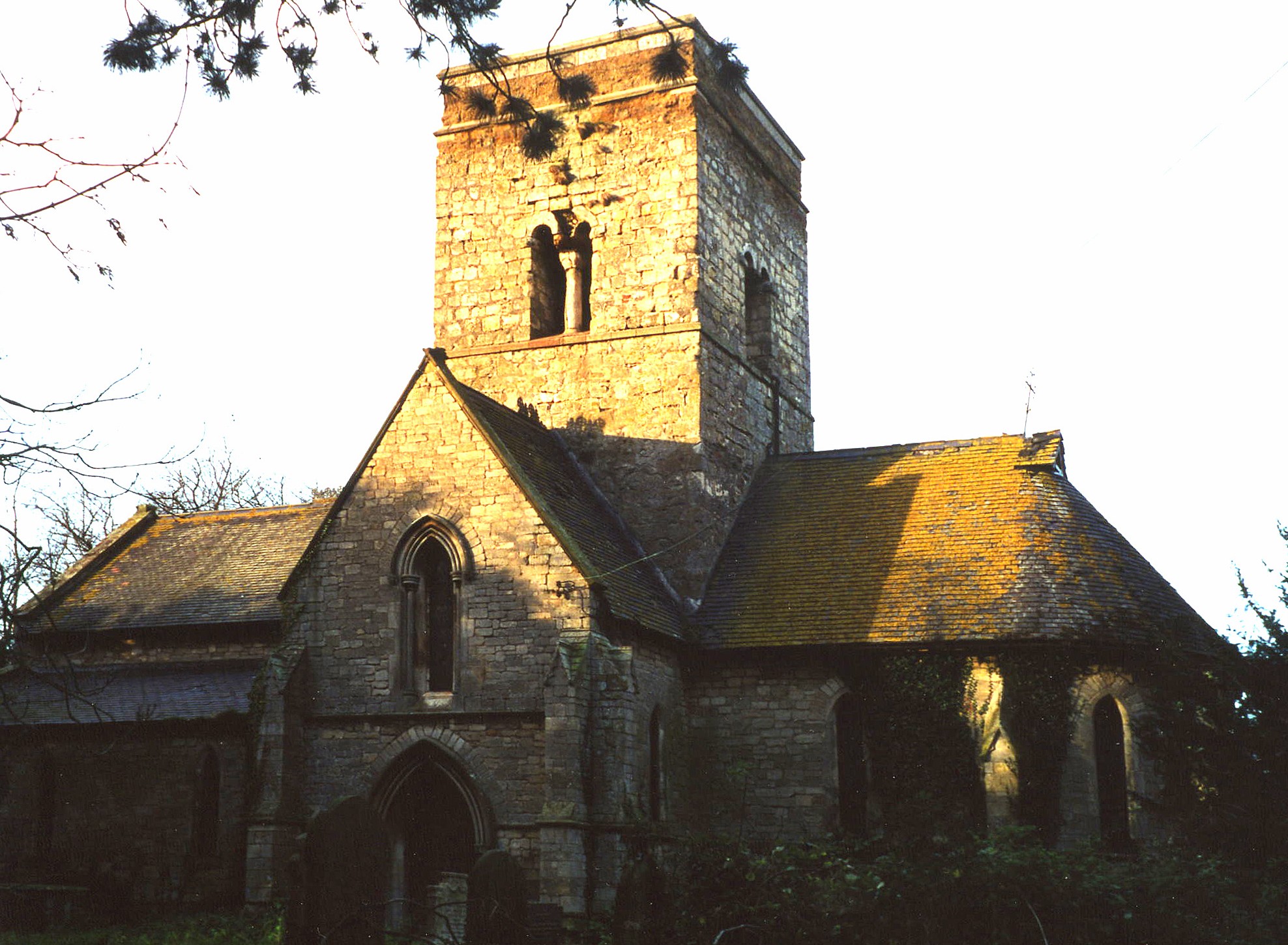
- The Anglican parish church is dedicated to Saint Martin.
- The church dates from early Norman times. It was entirely rebuilt in 1869.
- The church seats about 100 people.
- The church was declared redundant by the Diocese of Lincoln in July, 2002.
- The church is a Grade I listed structure with English Heritage.
- David HITCHBORNE has a photograph of St Martin's Church on Geo-graph, taken in June, 2004.
- Richard CROFT has a photograph of the church interior of this beautiful little church on Geo-graph, taken in February, 2008.
- Here is a photo of St. Martin's Church, taken by Ron COLE (who retains the copyright):
- The Anglican parish register dates from 1698.
- We have started a parish register extract. Your additions to this are welcome.
- The Lincolnshire FHS has published several marriage indexes and a 1641/2 Protestation Return for the Haverstoe Deanery to make your search easier.
- Some 1900 Lincolnshire Directories show the parish in the rural deanery of South Grantham.
- Check our Church Records page for county-wide resources.
- The parish was in the Tetney sub-district of the Louth Registration District.
- Check our Civil Registration page for sources and background on Civil Registration which began in July, 1837.
Waithe (or Waythe) is a small parish and village on the road between Louth and Grimsby. Tetney parish is to the north-east and Grainsby parish to the south. The parish is a long, narrow rectangle, siting like a pedestal under Holton le Clay parish, and it covers only about 750 acres.
The Tetney rivulet runs near the village. If you are planning a visit:
- By automobile, take the A16 trunk road south out of Grimsby for about 6 miles.
- See our touring page for visitor services.
The National Gazetteer of Great Britain and Ireland - 1868
- Ask for a calculation of the distance from Waithe to another place.
- See our Maps page for additional resources.
You can see maps centred on OS grid reference TA284007 (Lat/Lon: 53.487354, -0.066292), Waithe which are provided by:
- OpenStreetMap
- Google Maps
- StreetMap (Current Ordnance Survey maps)
- Bing (was Multimap)
- Old Maps Online
- National Library of Scotland (Old Ordnance Survey maps)
- Vision of Britain (Click "Historical units & statistics" for administrative areas.)
- English Jurisdictions in 1851 (Unfortunately the LDS have removed the facility to enable us to specify a starting location, you will need to search yourself on their map.)
- Magic (Geographic information) (Click + on map if it doesn't show)
- GeoHack (Links to on-line maps and location specific services.)
- All places within the same township/parish shown on an Openstreetmap map.
- Nearby townships/parishes shown on an Openstreetmap map.
- Nearby places shown on an Openstreetmap map.
- Adrian S. PYE has a photograph of an RAF Memorial to four aircrews on Geo-graph, taken in August, 2019.
For a photograph of the Waithe Roll of Honour and a list of the names on it, see the Roll of Honour site.
- This place was an ancient parish in county Lincoln and became a modern Civil Parish when those were established.
- The parish was in the ancient Bradley Haverstoe Wapentake in the East Lindsey district in the parts of Lindsey.
- The parish is part of the "North Thoresby, Grainsby and Waithe Parish Council".
- For today's district governance, see the East Lindsey Govt. Council.
- Bastardy cases would be heard in the Louth Petty Session Court every other Wednesday.
- After the Poor Law Amendment Act of 1834, the parish became part of the Louth Poorlaw Union.
- The children of Waithe attended school in North Thoresby.
- For more on researching school records, see our Schools Research page.