
Hide
Whitton
hide
Hide
hide
Hide
hide
Hide
Hide
"READ'S ISLAND, a shoal in the river Humber, in the parish of Whitton, county Lincoln, near Whittonness. Until recently it formed part of the Pudding-Pie Sand, but has been reclaimed, and now affords good pasturage."
[Transcribed from The National Gazetteer of Great Britain and Ireland 1868]
by Colin Hinson ©2020
Hide
A Reading Room and Library were established in 1884.
The Scunthorpe Library is an excellent resource with a Local History section.
Alternatively, the Brigg Library also has a Local History section.
- Tony KIRWAN has a good view of the church tower and graveyard in a photograph, taken in June, 2010.
- Neil THEASBY also has a photograph of the churchyard on Geo-graph, taken in February, 2017.
- Martin DAWES has a photograph of the gravestone of James William RICHE on Geo-graph, taken in May, 2012.
- Whitton was in the Winterton sub-district of the Glanford Brigg Registration District.
- Check our Census Resource page for county-wide resources.
- The table below gives census piece numbers, where known:
| Census Year | Piece No. |
|---|---|
| 1841 | H.O. 107 / 648 |
| 1851 | H.O. 107 / 2117 |
| 1861 | R.G. 9 / 2400 |
| 1871 | R.G. 10 / 3432 |
| 1881 | R.G. 11 / 3287 |
| 1891 | R.G. 12 / 2627 & 2628 |
| 1901 | R.G. 13 / 3104 |
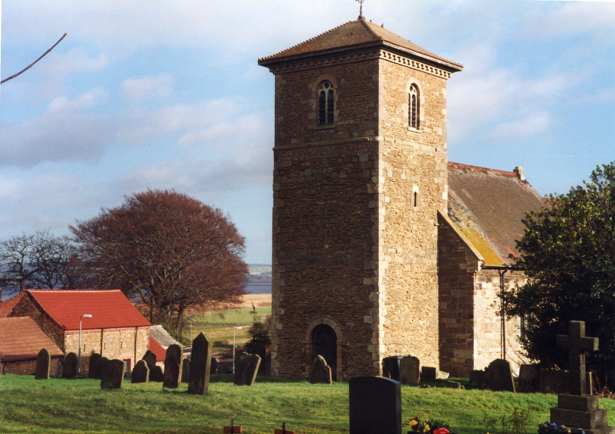
- The Anglican parish church is dedicated to Saint John the Baptist.
- The church was partially rebuilt in 1892.
- The church tower was restored in 1897.
- The church seats 200.
- There is a photograph of St. John the Baptist's Church on the Wendy PARKINSON Church Photos web site.
- Mat FASCIONE has a side-view photograph of St. John the Baptist Church on Geo-graph, taken in August, 2016.
- Here is a photo of Saint John's Church, taken by Ron COLE (who retains the copyright):
- Parish register entries start in 1562. (One source gives a start year of 1546, but claims that the early years are "in a bad state and illegible".)
- The LFHS has published several marriage indexes for the Manlake Deanery to make your search easier
. - Check our Church Records page for county-wide resources.
- The parish was in the Winterton sub-district of the Glanford Brigg Registration District.
- Check our Civil Registration page for sources and background on Civil Registration which started in July, 1837.
This parish is one of the two northern-most of Lincolnshire - any further north and you are standing in the River Humber. Bordered on the south by West Halton parish and on the east side by Winteringham parish. The parish is 3 miles below Trent Falls and contains the hamlet of Bishopthorpe, just south of Whitton village.
Long a ferry crossing on the Humber, Whitton is far enough upstream that most of the river can be crossed on foot at low tide, except for the dedged channel. If you are planning a visit:
- From Scunthorpe, take the A1077 north almost to Winteringham and turn left about a mile before that village to West Halton. From West Halton, Whitton is a mile north.
- See our touring page for visitor services.
The National Gazetteer of Great Britain and Ireland - 1868
"READ'S ISLAND, a shoal in the river Humber, in the parish of Whitton, county Lincoln, near Whittonness. Until recently it formed part of the Pudding-Pie Sand, but has been reclaimed, and now affords good pasturage."
- Ask for a calculation of the distance from Whitton to another place.
- The Romans are believed to have built a causeway partway across the River Humber here as a partial ford.
- In 1868 a 200-yard-long pier was opened on the Humber providing daily berthing for steam packets and fishing boats.
- The railway came to Whitton in 1910, but service was discontinued around 1960.
- See our Maps page for additional resources.
You can see maps centred on OS grid reference SE902243 (Lat/Lon: 53.70758, -0.63446), Whitton which are provided by:
- OpenStreetMap
- Google Maps
- StreetMap (Current Ordnance Survey maps)
- Bing (was Multimap)
- Old Maps Online
- National Library of Scotland (Old Ordnance Survey maps)
- Vision of Britain (Click "Historical units & statistics" for administrative areas.)
- English Jurisdictions in 1851 (Unfortunately the LDS have removed the facility to enable us to specify a starting location, you will need to search yourself on their map.)
- Magic (Geographic information) (Click + on map if it doesn't show)
- GeoHack (Links to on-line maps and location specific services.)
- All places within the same township/parish shown on an Openstreetmap map.
- Nearby townships/parishes shown on an Openstreetmap map.
- Nearby places shown on an Openstreetmap map.
- David WRIGHT has a photograph of the Roll of Honour inside the parish church in a photograph, taken in June, 2011.
- Steve PARKER has captured a bit of World War II history in a photograph, taken in May, 2005.
- Neal THEASBY has a photograph of the Church Roll of Honour on Geo-graph, taken in February, 2017.
The Imperial War Museum tells us that these are the names from both World Wars on the oaken War Memorial in the church (all died in combat):
- Barley, Frank
- Bray, Robert
- Foster, Percy
- Spilman, Henry
- Spilman, Thomas L. N.
- Standerline, Harry
- The name Whitton is from the Old English hwitan+eg, or "White Island". In the 1086 Domesday Book, the village name is little-changed, given as Witenai.
[A. D. Mills, "A Dictionary of English Place-Names," Oxford University Press, 1991]
- This place was an ancient parish in county Lincoln and became a modern Civil Parish when those were established.
- The parish was in the ancient Manley Wapentake in the Glanford district in the parts of Lindsey.
- Jonathan THACKER has a photograph of the Village Hall (under contruction) on Geo-graph, taken in February, 2014.
- District governance is provided by the North Lincolnshire Council.
- Bastardy cases would be heard at the Winterton petty session hearings.
- As a result of the 1834 Poor Law Amendment Act, this parish became part of the Glanford Brigg Poor Law Union.
- In 1882, Mrs. BORDS left the interest on £50 to purchase flannel for old poor widows not on parochial relief.
- Nathaniel EASTON bestowed in 1886 the interest on £150 to distribute to the poor of the parish annually.
- A National School was built here in 1864.
- Richard CROFT has a photograph of the National School in a photograph, taken in 2008. The school building now functions as the village hall.
- For more on researching school records, see our Schools Research page.