
Hide
St Benet Gracechurch-street
hide
Hide
hide
Hide
Hide
Hide
"ST. BENNET'S, GRASS-CHURCH, or GRACECHURCH, the church of, is situated at the southwest corner of Fenchurch-street and Gracechurch-street, nearly opposite Lombard-street. It derives its name from its dedication to St. Benedict, or Bennet, and its vicinity to the Grass-market, which was anciently held before its western door. The old church was destroyed by the great fire in 1666, and rebuilt by Sir Christopher Wren. . . The Church of St. Leonard, Eastcheap, was also destroyed at the same time, and the present church is now the parochial church of the two united parishes. It is a rectory, the patronage of which appears to have remained in the Dean and Chapter of St. Paul's; but as the patronage of the rectory of St. Leonard was anciently in the Priors and Convent of Canterbury, and since the Reformation, in the Dean and Chapter of that see, of which it is one of the thirteen peculiars within the City, the presentation is alternately with St. Paul's and Canterbury. The present rector is the Rev. George Gaskin, D.D. a prebendary of Ely, who was instituted by the Dean and Chapter of St. Paul's in 1791." [James Elmes. A Topographical Dictionary of London and its Environs (1831) - transcribed by Brian Randell]
Hide
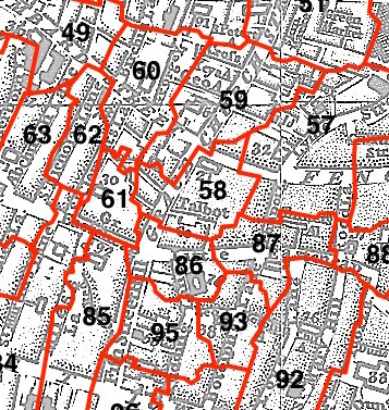
This parish - no. 58 in the above map - is located in Bridge and Bridge Without Ward.
The church was destroyed in 1666, rebuilt by Wren, demolished 1867.
The parish was later united with Allhallows Lombard Street 1864, St Edmund the King and Martyr 1937.
Hide
London Metropolitan Archive holdings for St Benet Gracechurch-street.
John Kent at the Three Tuns Taverns - in the Mr Pepys' Small Change website.
Online Parish Register Images and Indexes for St Benet Gracechurch-street parish are provided by, or at various subscription sites via, the LDS FamilySearch wiki.
Non-Church of England denominations identified in St Benet Gracechurch with St Leonard Eastcheap include: Baptist and Independent/Congregational [LDS FamilySearch Wiki].
Wikipedia page on St Benet Gracechurch-street.
- Ask for a calculation of the distance from St Benet Gracechurch-street to another place.
Summary history of St Benet Gracechurch-street parish, from the Worshipful Company of Parish Clerks.
Public Houses, Inns & Taverns of the parish of St Benet Gracechurch-street - provides "information from census records, trade directories, etc."
You can see maps centred on OS grid reference TQ330809 (Lat/Lon: 51.511461, -0.085364), St Benet Gracechurch-street which are provided by:
- OpenStreetMap
- Google Maps
- StreetMap (Current Ordnance Survey maps)
- Bing (was Multimap)
- Old Maps Online
- National Library of Scotland (Old Ordnance Survey maps)
- Vision of Britain (Click "Historical units & statistics" for administrative areas.)
- English Jurisdictions in 1851 (Unfortunately the LDS have removed the facility to enable us to specify a starting location, you will need to search yourself on their map.)
- Magic (Geographic information) (Click + on map if it doesn't show)
- GeoHack (Links to on-line maps and location specific services.)
- All places within the same township/parish shown on an Openstreetmap map.
- Nearby townships/parishes shown on an Openstreetmap map.
- Nearby places shown on an Openstreetmap map.
Surnames from the 1881 census in the St Benet Gracechurch district.
Clerical career summaries for the parish of (i) St Benet Gracechurch-street and (ii) St Benet Gracechurch With St Leonard Eastcheap, from the Clergy of the Church of England Database website.
Sources for listings of taxpayer names for St Benet Gracechurch-street parish, listed on the LDS FamilySearch wiki.