
Hide
Lund
hide
Hide
hide
Hide
Hide
The Ancient Parish of LUND
[Transcribed information mainly from the early 1820s]
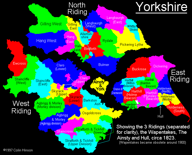
"LUND, a parish in the wapentake of Harthill; 8 miles NW. of Beverley. The church is dedicated to All Saints (see Churches for photograph), and the living, which is a vicarage, is in the patronage of T. Grimston, Esq. In the Market place are the remains of a cross, at which place goods are exposed for sale every Thursday in Lent. Here is also an old seat of the Jarratt family, now occupied by a farmer. There is in this place a public school, for an unlimited number of children, erected by the parishioners. Pop. 357.""ENTHORPE, a farm house in the parish of Lund, and wapentake of Harthill; 3½ miles WSW. of Lund, 4 miles NE. of Market Weighton."
[Description(s) edited mainly from various 19th century sources by Colin Hinson. ©2010]
Hide
- Photographs of over 200 gravestones in Lund Churchyard with a surname index.
- The Benefaction in All Saints Church, Lund.
- Here are photographs of Churches etc. in the parish:
- All Saints' Church, Lund.
- Internal view looking down the aisle
- The East Window
- The font
- The Methodist Church and the old School, Lund.
- All Saints' Church, Lund.
- Transcript of the entry for Lund in the "Collections relative to Churches and Chapels".
- The whereabouts and dates of the Registers etc. for the Parish of Lund.
- The List of Vicars in Lund church.
- Transcript of the entry of "professions and trades" in the Baines's Directory of 1823, of the East Riding.
- Transcript of the entry of "professions and trades" in the The Post Office Directory of the, East and North Ridings, 1857
- Transcript of the entry of "professions and trades" in the Bulmers Directory of 1892. of the East Riding.
- There is further information about this parish from the National Gazetteer 1868, Yorkshire extracts.
- There is further information about this parish from the Lewis's Topographical Dictionary of England 1835, Yorkshire extracts.
- There is further information about this parish from the Stephen Whatley's Gazetteer 1750, Yorkshire extracts.
- There is further information about this parish from the Bulmer's 1892 History and Directory of the East Riding.
- Ask for a calculation of the distance from Lund to another place.
- For a detailed map of this parish see this parish boundaries map.
- For a more detailed map of the parishes in the riding please see the Yorkshire parish maps page.
- For a more detailed map of the county please see the Yorkshire map page.
- Here is a map showing the wapentakes for the county.
You can see maps centred on OS grid reference SE970482 (Lat/Lon: 53.920866, -0.524483), Lund which are provided by:
- OpenStreetMap
- Google Maps
- StreetMap (Current Ordnance Survey maps)
- Bing (was Multimap)
- Old Maps Online
- National Library of Scotland (Old Ordnance Survey maps)
- Vision of Britain (Click "Historical units & statistics" for administrative areas.)
- English Jurisdictions in 1851 (Unfortunately the LDS have removed the facility to enable us to specify a starting location, you will need to search yourself on their map.)
- Magic (Geographic information) (Click + on map if it doesn't show)
- GeoHack (Links to on-line maps and location specific services.)
- All places within the same township/parish shown on an Openstreetmap map.
- Nearby townships/parishes shown on an Openstreetmap map.
- Nearby places shown on an Openstreetmap map.
- The World War I Roll of Honour in All Saints Church, Lund.
- The Notice of the Militia Assembly in All Saints Church, Lund.
- This parish is covered by the following Society:
- The 1834 Electoral Roll for this parish