
Hide
Arkengarthdale
hide
Hide
hide
Hide
Hide
The Ancient Parish of ARKENGARTHDALE
[Transcribed information mainly from the early 1820s]
"ARKENGARTHDALE, a parish in the wapentake of Gilling West, and liberty of Richmondshire. The Dale is about 7 or 8 miles in length, commencing at Dale head, running in a SE. direction, and terminating in the town of Reeth. There is a small but neat stone church, (lately erected, the old one being in ruins) situated near the most populous part of the Dale, consecrated in 1820, and dedicated to St. Mary (see Churches for photograph). The living is a perpetual curacy, in the patronage of Lord Viscount (John) Lowther, there is likewise a Methodist chapel built by subscription, and a free school built and endowed by the late George Brown, Esq. of Stockton, lord of the manor, the school and books are free for all children residing in the Dale, the endowment is £60. per annum, paid out of the rents of the manor, the master has also a house and a piece of land. The inhabitants of Arkengarthdale are principally miners, and Arkengarthdale possesses one of the most productive fields of lead ore, worked at the present day, and a smelting mill the most complete and extensive in the country. Population, 1512.The present Church was erected through the benefaction of the late George Brown, Esq. the foundation stone of which was laid September 24, 1817, and an inscription to that effect is upon the Church. This parish, of small extent, is co-extensive with the township, and inhabited chiefly by miners. The lead mines here, appear to have been worked as early as the reign of King John. The annual produce of the mines, carried on under the firm of the Arkengarthdale and Darwent Mining Company, was some few years ago, estimated at 2000 tons. It is a narrow dale on the north-side of Swaledale"
Information on the following places in this Parish is contained on a supplementary page.
|
|
[Description(s) edited mainly from various 19th century sources by Colin Hinson. ©2010]
Hide
- Please see Christine Amsden's Census pages for the following Census transcriptions:
- Arkengarthdale: 1841, 1851, 1861, 1871, 1891, 1901
- Here are photographs of:
- St. Mary's Church, Langthwaite.
- Internal view looking down the aisle
- The two fonts
- The notice about the two fonts
- Another view of St. Mary's Church, Langthwaite.
- A photograph inside St. Mary's Church in 1900.
- List of the Vicars of Arkengarthdale inside St. Mary's Church.
- The old Graveyard at Arkle Town.
- The Wesleyan Chapel at Langthwaite.
- another view of The Wesleyan Chapel at Langthwaite.
- The ex-Wesleyan Chapel at Whaw.
- St. Mary's Church, Langthwaite.
- Transcript of the entry for Arkengarthdale in the "Collections relative to Churches and Chapels".
- The whereabouts and dates of the Registers etc. for the Parish of Arkengarthdale.
- The List of Incumbents in St. Mary's Church, Langthwaite (Arkengarthdale).
- Here are photographs of the Arkengarthdale area:
- Looking up Arkengarthdale from above Arkle Town.
- As above, but with place description overlay..
- Looking down Arkengarthdale from above Arkle Town, towards Swaledale (on a rainy day).
- Looking down Arkengarthdale, from Arkle Town Old Graveyard towards Swaledale (on a sunny day).
- Looking across the mountain tops from 1700ft., across Stainmoor.
- Looking down Arkengarthdale from upper Arkengarthdale.
- The hamlet of Booze.
- The hamlet of Whaw.
- Transcript of the entry of "professions and trades" in the Baines's Directory of 1823, of the North Riding.
- Transcript of the entry of "professions and trades" in the White's Directory of 1840, Yorkshire section.
- Transcript of the entry of "professions and trades" in the Bulmers Directory of 1890. of the North Riding.
- There is further information about this parish from the National Gazetteer 1868, Yorkshire extracts.
- There is further information about this parish from the Lewis's Topographical Dictionary of England 1835, Yorkshire extracts.
- There is further information about this parish from the Bulmer's 1890 History and Directory of the North Riding.
- Ask for a calculation of the distance from Arkengarthdale to another place.
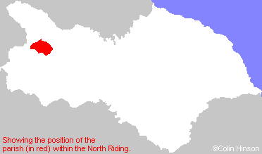
- For a detailed map of this parish see this parish boundaries map.
- For a more detailed map of the parishes in the riding please see the Yorkshire parish maps page.
- For a more detailed map of the county please see the Yorkshire map page.
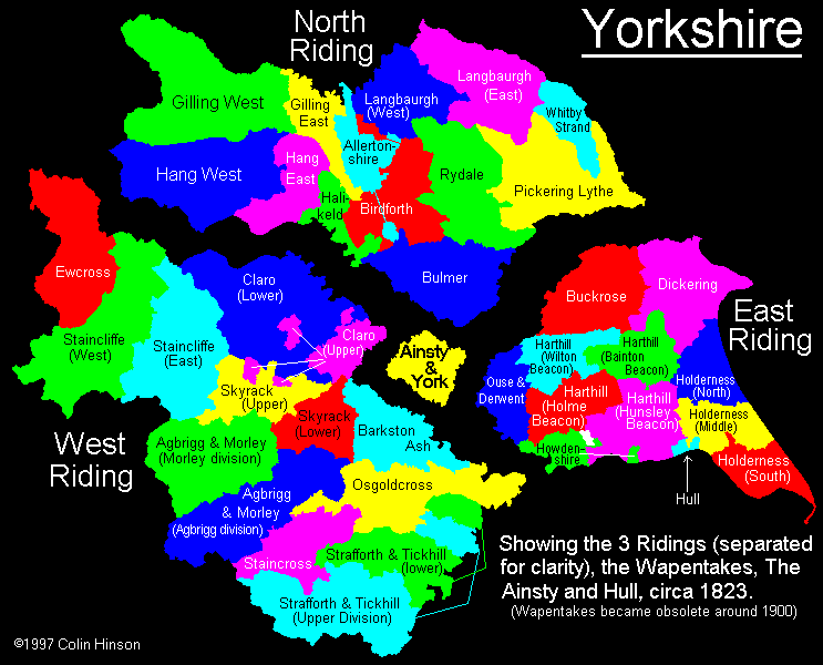
- Here is a map showing the wapentakes for the county.
You can see maps centred on OS grid reference NZ005025 (Lat/Lon: 54.417942, -1.993802), Arkengarthdale which are provided by:
- OpenStreetMap
- Google Maps
- StreetMap (Current Ordnance Survey maps)
- Bing (was Multimap)
- Old Maps Online
- National Library of Scotland (Old Ordnance Survey maps)
- Vision of Britain (Click "Historical units & statistics" for administrative areas.)
- English Jurisdictions in 1851 (Unfortunately the LDS have removed the facility to enable us to specify a starting location, you will need to search yourself on their map.)
- Magic (Geographic information) (Click + on map if it doesn't show)
- GeoHack (Links to on-line maps and location specific services.)
- All places within the same township/parish shown on an Openstreetmap map.
- Nearby townships/parishes shown on an Openstreetmap map.
- Nearby places shown on an Openstreetmap map.
- The World War I and II memorial at Langthwaite in Arkengarthdale.
- This parish is covered by the following Society: