
Hide
Gargrave
hide
Hide
hide
Hide
Hide
The Ancient Parish of GARGRAVE
[Transcribed information mainly from the early 1820s]
"GARGRAVE, a parish-town, in the east-division of Staincliffe, liberty of Clifford's-Fee; (Gargrave House, the seat of John Nicholas Coulthurst, Esq.) 4½ miles NW. of Skipton, 8 from Gisburn, 11½ from Settle, 12 from Colne, (Lanc.) 14 from Kettlewell, 45 from York. No Market. Fairs, Feb. 27, third Wednesday in June, October 13, and December 11, for horned cattle, &c. Pop. 972. The Church is a vicarage, dedicated to St. Andrew (see Churches for photograph), in the deanry of Craven, value, £12. 13s. 11½d. Patron, John Marsden, Esq.About half a mile beneath the town, on a fertile plain, are the buried remains of a Roman Villa, called Kirk Sink, from a tradition that some great ecclesiastical edifice had here been swallowed up. The stones of which this building has been composed have gradually been removed, probably to build the present church; but the inequalities upon the surface, prove it to have been a parallelogram, about 300 feet long, and 180 wide. It was dug into, about 70 years ago, and the frame of a tessellated pavement discovered at that time, of which Dr. Whitaker had seen some remains, which induced him to apply for permission to open the ground again. But the walls had been so completely grubbed up to the foundation, that though it was just possible to ascertain the size of the apartments, which had been very small, no masses of cohering pavement could be taken up, and the whole lay in heaps mingled with mortar, consisting of cubes of various colours, some an inch, others not more than half an inch in diameter, together with floor tiles, of about three inches square. --Whitaker's Craven."
Information on the following places in this Parish is contained on a supplementary page.
|
|
[Description(s) edited from various 19th century sources by Colin Hinson © 2013]
Hide
- Garry Stockdill's Yorksview website contains a description and photographs of Gargrave.
- The following are on the KirkbyMalham.info website:
- 1841 Census : Transcript of Bell Busk & Coniston Cold - HO107/1321/1 fo.3-8b
- 1851 Census : Transcript of Bell Busk & Coniston Cold - HO107/2276 fo. 79-86 + part of Bell Busk enumerated within Airton- HO107 / 2277 fo.466b-467
- 1861 census : Transcript of Bell Busk & Coniston Cold - RG9/3183 fo. 22-26b + part of Bell Busk enumerated within Airton- RG 9/3180 fo.29b
- 1871 Census : Transcript of Bell Busk & Coniston Cold - RG10/4260 fo. 19-25b + part of Bell Busk enumerated within Airton- RG10/4257 fo.28
- 1881 Census : Transcript of Bell Busk & Coniston Cold - RG11/4303 fo. 21b-28 + part of Bell Busk enumerated within Airton - RG11 /4300 fo.20
- 1891 Census : Transcript of Bell Busk & Coniston Cold - RG12 3498 fo. 20b-27b + part of Bell Busk enumerated within Airton - RG12/3495 fo.23
- 1901 Census : Transcript of Bell Busk & Coniston Cold - RG13/4026 fo. 19-23b + part of Bell Busk enumerated within Airton - RG13/4023/20
- 1911 Census : Transcript of Bell Busk & Coniston Cold - RG14/25756/..... + part of Bell Busk enumerated within Airton RG14/25746/...
- 1841 Winterburn Census : Transcript of HO107 / 1315 / 21 fo. 2b-3a
- 1851 Winterburn Census : Transcript of HO107 / 2278 fo. 67b-69
- 1861 Winterburn Census : Transcript of RG9 / 3183 fo.12b-13
- 1871 Winterburn Census : Transcript of RG10 / 4260 fo. 12-13
- 1881 Winterburn Census : Transcript of RG11 / 4303 fo.12-14
- 1891 Winterburn Census : Transcript of RG12 / 3498 fo. 12-13b
- 1901 Winterburn Census : Transcript of RG13/4026/fo.11b-12b
- 1911 Winterburn Census : Transcript of RG14/25755/fo.23-39
- 1841 Eshton Census : Transcript of HO107/1315/19 fo.3a-4
- 1851 Eshton Census : Transcript of HO107 / 2276/ fo.76b-78
- 1861 Eshton Census : Transcript of RG9 / 3187 /fo.20-21
- 1871 Eshton Census : Transcript of RG10 / 4260 / fo.24b-25b
- 1881 Eshton Census : Transcript of RG11 / 4303/ fo.20-21
- 1891 Eshton Census : Transcript of RG12 / 3498/ fo.19-20a
- 1901 Eshton Census : Transcript of RG13/4026/fo.17-18
- 1911 Eshton Census : Transcript of RG14/25756/.......
- Here are photographs of Churches etc. in the parish:
- St Andrew's Church, Gargrave (in the summer).
- Internal view looking down the nave
- St Andrew's Church, Gargrave (in the early spring).
- St Peter's Church, Coniston Cold.
- The former Methodist Church, Gargrave (now dis-used, see below for web-site).
- St Andrew's Church, Gargrave (in the summer).
- Winterburn Chapel : Baptism transcript and history
- Bell Busk Wesleyan Chapel and St Peter's, Coniston Cold
- A transcription of the Winterburn Congregational Church History
- Transcript of the entry for Gargrave in the "Collections relative to Churches and Chapels".
- Finding pre-1840 records for Coniston Cold and Bell Busk
- Gargrave Parish Records1558-1812
- The whereabouts and dates of the Registers etc. for the Parish of Gargrave.
- The list of Vicars at St Andrew's church, Gargrave
- Garry Stockdill's Yorksview website contains a description and photographs of Gargrave.
- Transcript of the entry of "professions and trades" in the Baines's Directory and Gazetteer, Vol I, West Riding.
- Transcript of the entry of "professions and trades" in the Craven Household Almanack 1911, XXX
- There is further information about this parish from the Pigot's 1834 Directory, Yorkshire section.
- There is further information about this parish from the National Gazetteer 1868, Yorkshire extracts.
- There is further information about this parish from the Lewis's Topographical Dictionary of England, Yorkshire extracts.
- There is further information about this parish from the Stephen Whatley's Gazetteer 1750, Yorkshire extracts.
- Ask for a calculation of the distance from Gargrave to another place.
- Procter of Bordley and Winterburn: Extract from JW Morkill's The Parish of Kirkby Malhamdale
- Wilson of Eshton Hall
- Bell Busk Mill
- Whitaker's History of Craven - Eshton
- Winterburn History : A timeline of events from pre-history to the 20th Century which includes many details of people and events.
- A transcription of the Winterburn Congregational Church History
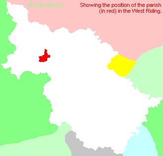
- For a detailed map of this parish see this parish boundaries map.
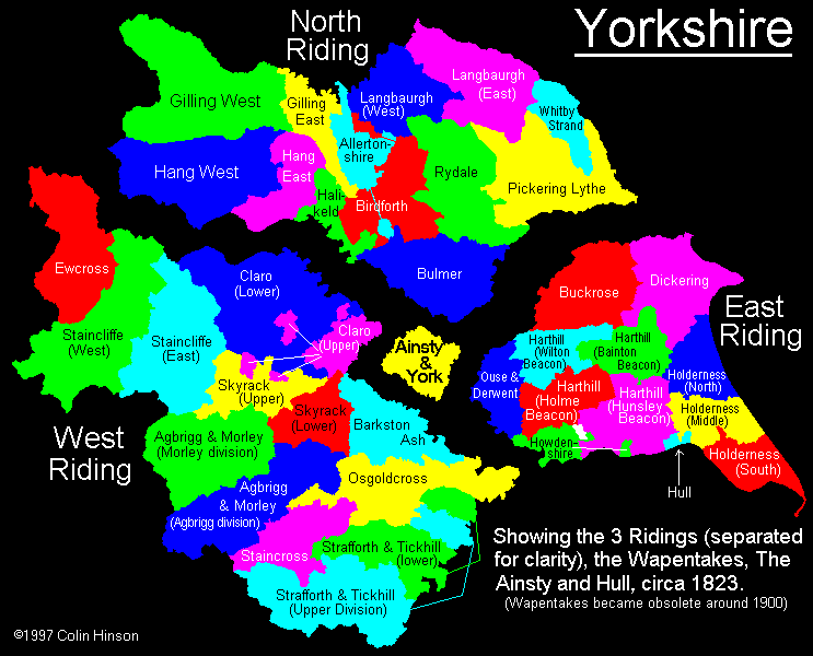
- For a more detailed map of the parishes in the riding please see the Yorkshire parish maps page.
- For a more detailed map of the county please see the Yorkshire map page.
- Here is a map showing the wapentakes for the county.
- Jeffreys' map : 1771
You can see maps centred on OS grid reference SD931543 (Lat/Lon: 53.984705, -2.106711), Gargrave which are provided by:
- OpenStreetMap
- Google Maps
- StreetMap (Current Ordnance Survey maps)
- Bing (was Multimap)
- Old Maps Online
- National Library of Scotland (Old Ordnance Survey maps)
- Vision of Britain (Click "Historical units & statistics" for administrative areas.)
- English Jurisdictions in 1851 (Unfortunately the LDS have removed the facility to enable us to specify a starting location, you will need to search yourself on their map.)
- Magic (Geographic information) (Click + on map if it doesn't show)
- GeoHack (Links to on-line maps and location specific services.)
- All places within the same township/parish shown on an Openstreetmap map.
- Nearby townships/parishes shown on an Openstreetmap map.
- Nearby places shown on an Openstreetmap map.
- The War Memorial at Coniston Cold.
- The Memorial plaque in Gargrave Church.
- The Roll of Honour in the church at Gargrave.
- The War Memorial at Gargrave.
- Will extract - Edmund Rimington, Winterburn 1661
- This parish is covered by the following Society:
- A list of those paying the 1379 Subsidy Rolls (Poll Tax) for this parish.