
Hide
Guiseley
hide
Hide
hide
Hide
Hide
The Ancient Parish of GUISELEY
[Transcribed information mainly from the early 1820s]
"GUISELEY, a parish-town, in the upper-division of the wapentake of Skyrack, liberty of Cawood, Wistow, and Otley; 2 miles S. of Otley, 9 from Bradford, 10 from Leeds, 29 from York. Pop. 1,213. The Church is a rectory, dedicated to St. Oswald (see Churches for photograph), in the deanry of the Ainsty, value, £26. Patron, Trinity College, Cambridge.Trinity College, Cambridge, "has only the third turn of presentation, which is the next." Camb. Caland. 1822."
Information on the following places in this Parish is contained on a supplementary page.
|
|
[Description(s) edited from various 19th century sources by Colin Hinson © 2013]
Hide
- The Horsforth census for 1795 has been transcribed by Marilyn Maybury.
- Here are photographs of Churches in the parish:
- St Oswald's Church, Guiseley.
- The Methodist Church, Guiseley.
- The Baptist Church, Guiseley.
- The former St. Bartholomew's Church, Carlton, now a private house.
- The Old Church site, Horsforth (view 1).
- The Old Church site, Horsforth (view 2). This photo. and the one above show the location of the original church in Horsforth, which was demolished in the 19th century, when St Margarets was built. The low wall is supposedly on the line of the original church walls.
- St. Margaret's Church, Horsforth (view 1). (The Church's website is here.)
- St. Margaret's Church, Horsforth (view 2).
- St. James's Church, Woodside. (The Church's website is here.)
- The Central Methodist Church, Horsforth.
- The Grove Methodist Church, Horsforth. (The Church's website is here.)
- Cragg Hill Baptist Church, Horsforth (view 1). This used to be the Zion Chapel.
- Cragg Hill Baptist Church, Horsforth (view 2).
- Providence Chapel, Horsforth.
- Woodside Methodist Church, Horsforth.
- Richard Thomson (who took the above photograph) has also written a short History of the Church.
- Bachelor Lane Methodist Church, Horsforth (view 1).
- Bachelor Lane Methodist Church, Horsforth (view 2).
- St. Mary's Roman Catholic Church, Horsforth.
- The Kingdom Hall of Jehovah's Witnesses, Horsforth.
- St. Peter's Church, Rawdon.
- The Meeting Hall of the Society of Friends, Rawdon. (The Church's website is here.)
- The Christian Science Church, Rawdon.
- Trinity Church (Methodist; Baptist and URC), Rawdon - so named because it houses the Baptist, Methodist and United Reformed Churches.
- The former St. Andrew's Church, Yeadon (built in 1894), now the New Life Community Church. (The Church's website is here.)
- St. John's Church, Yeadon. (View 1)
- St. John's Church, Yeadon. (View 2)
- The Methodist Church, Yeadon.
- Willow Green Christian Fellowship, Horsforth.
- The Roman Catholic Church of St. Peter and St. Paul, Yeadon.
- Lister Hill Baptist Church, Horsforth.
- The (Plymouth) Brethren's Meeting room, Horsforth.
- Richard Thomson has also written a short History of Woodside Methodist Church.
- A transcription of Rawdon Cragg Baptist Church History
- A transcription of Guiseley Baptist Church History
- A transcription of Horsforth Baptist Church History
- Transcript of the entry for Guiseley in the "Collections relative to Churches and Chapels".
- Transcript of the entry for Horseforth in the "Collections relative to Churches and Chapels".
- Transcript of the entry for Rawden in the "Collections relative to Churches and Chapels".
- The following transcriptions are transcriptions of transcriptions originally done in 1988 by Wath and Mexborough Archives. These documents have many typographical errors and so we cannot vouch for the accuracy in the original transcription. If you find anything of interest here, please be sure to check the original Parish Registers source material.
Transcriptions by Jack Parry of:- The Baptism Registers for St. Oswald's Church, Guiseley:
- The Marriage Registers for St. Oswald's Church, Guiseley:
- A transcription of the Marriage Banns 1832 to 1838 with a few from January 1839
- The Burial Registers for St. Oswald's Church, Guiseley:
- The Baptism Registers for Rawdon Chapel, Guiseley PRs:
- The Burial Registers for Horsforth Chapel:
- The Baptism Registers for Rawdon Chapel, Guiseley PRs:
- The Burial Registers for Rawdon Chapel, Guiseley PRs:
- The whereabouts and dates of the Registers etc. for the Parish of Guiseley.
- The whereabouts and dates of the Registers etc. for the Chapelry of Horsforth.
- The whereabouts and dates of the Registers etc. for the Chapelry of Rawdon.
- Garry Stockdill's Yorksview website contains a description and photographs of Rawdon.
- Transcript of the entry of "professions and trades" in the Baines's Directory and Gazetteer, Vol I, West Riding.
- Transcript of the entry of "professions and trades" in the Pigot's 1834 Directory, Yorkshire section.
- There is further information about this parish from the Pigot's 1834 Directory, Yorkshire section.
- There is further information about this parish from the National Gazetteer 1868, Yorkshire extracts.
- There is further information about this parish from the Lewis's Topographical Dictionary of England, Yorkshire extracts.
- There is further information about this parish from the Stephen Whatley's Gazetteer 1750, Yorkshire extracts.
- Ask for a calculation of the distance from Guiseley to another place.
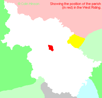
- For a detailed map of this parish see this parish boundaries map.
- For a more detailed map of the parishes in the riding please see the Yorkshire parish maps page.
- For a more detailed map of the county please see the Yorkshire map page.
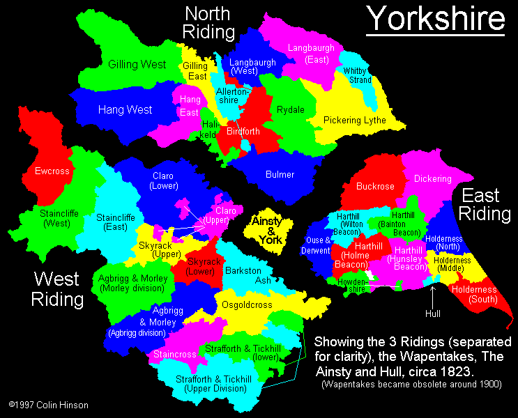
- Here is a map showing the wapentakes for the county.
You can see maps centred on OS grid reference SE188420 (Lat/Lon: 53.873867, -1.71555), Guiseley which are provided by:
- OpenStreetMap
- Google Maps
- StreetMap (Current Ordnance Survey maps)
- Bing (was Multimap)
- Old Maps Online
- National Library of Scotland (Old Ordnance Survey maps)
- Vision of Britain (Click "Historical units & statistics" for administrative areas.)
- English Jurisdictions in 1851 (Unfortunately the LDS have removed the facility to enable us to specify a starting location, you will need to search yourself on their map.)
- Magic (Geographic information) (Click + on map if it doesn't show)
- GeoHack (Links to on-line maps and location specific services.)
- All places within the same township/parish shown on an Openstreetmap map.
- Nearby townships/parishes shown on an Openstreetmap map.
- Nearby places shown on an Openstreetmap map.
- The following places are within the boundaries of this (ancient) parish, but I have no further information on them other than the Ordnance Survey Landranger Grid reference shown:
- (SE237374) Cragg Hill
- (SE220431) East Carlton
- (SE232425) Green Gates
- (SE203404) Henshaw
- (SE244376) Horsforth Woodside
- (SE226393) Lane Ends
- (SE214396) Larkfield
- (SE203397) Little London
- (SE231374) Low Fold
- (SE215390) Low Green
- (SE215387) Rawdon Carrs
- (SE219376) Wellroyd
- (SE208430) West Carlton
- (SE230383) West End
- The list of Horsforth Poor for 1767 has been transcribed by Marilyn Maybury.
- This parish is covered (or partly covered) by the following Societies:
- A list of those paying the 1379 Subsidy Rolls (Poll Tax) for this parish.