
Hide
Snaith
hide
Hide
hide
Hide
Hide
The Ancient Parish of SNAITH
[Transcribed information mainly from the early 1820s]
"SNAITH, a market and parish-town, in the wapentake of Osgoldcross, liberty and bailiwick of Cowick and Snaith; 7 miles from Thorne, 8 SE. of Selby, 10 from Howden, 11 from Ferrybridge, 14 from Pontefract, 23 from York, 175 from London. Market, Thursday. Fairs, last Thursday in April, for horned cattle, sheep, and woollen cloth, Aug. 10, for horned cattle, woollen cloth, line, cheese, and quills; and the last Thursday in Sept. which is chartered but not now attended. Principal Inns, Blue Bell, Black Lion, Bell and Crown, and Green Dragon. Pop. 834. The Church (see Churches for photograph), peculiar, is a perpetual curacy, dedicated to St. Mary, in the deanry of Pontefract. Patron, Henry Yarburgh, Esq.The town of Snaith is situated on a gently rising ground, about half a mile south of the river Aire, and within five miles of the junction of the Ouse with the rivers Derwent and Aire.
In the Church, which is a neat Gothic structure, is the family vault of Lord Viscount Downe, in which his ancestors lay interred.
At the west end of the town stands an old Hall, formerly the residence of the Yarburghs. The country round is extremely flat and uninteresting, but abundantly fertile. Flax is much cultivated in the neighbourhood."
Information on the following places in this Parish is contained on a supplementary page.
|
|
|
[Description(s) edited from various 19th century sources by Colin Hinson © 2013]
Hide
- Here are photographs of Churches etc. in the parish:
- St. Laurence Priory Church, Snaith.
- Internal view looking down the nave
- St. Laurence Priory Church, Snaith.
- The Methodist Church, Snaith.
- St David's Church, Airmyn.
- St Mary's Church, Carlton (view 1).
- St. Mary's Church, Carlton (view 2).
- The Roman Catholic Church, Carlton (also dedicated to St. Mary).
- The Methodist Church, Carlton.
- Holy Trinity Church, East Cowick, view 1 - they don't want you to see the church from the road!
- Holy Trinity Church, East Cowick, view 2.
- St James' Church, Rawcliffe.
- The Church of St. John the Evangelist, Goole.
- Trinity Methodist Church, Goole.
- The Central Methodist Church, Goole.
- St. Thomas's Roman Catholic Church (now dis-used), Old Goole.
- St. Joseph's Roman Catholic Church, Goole.
- The former United Reformed Church, Goole.
- St. Paul's Church, Hensall. (view 1)
- St. Paul's Church, Hensall. (view 2)
- The Methodist Church, Hensall.
- St. John the Baptist's Church, Great Heck.
- The former Wesleyan Chapel, Pollington, now a private dwelling.
- The Wesleyan Methodist Church, Rawcliffe Bridge, now a private dwelling.
- St. Laurence Priory Church, Snaith.
- A transcription of the Cowick Pollington Congregational Church History
- A transcription of the Goole Congregational Church History
- Transcript of the entry for Snaith in the "Collections relative to Churches and Chapels".
- Transcript of the entry for Airmin in the "Collections relative to Churches and Chapels".
- Transcript of the entry for Carlton in Balne in the "Collections relative to Churches and Chapels".
- Transcript of the entry for Goole in the "Collections relative to Churches and Chapels".
- Transcript of the entry for Hooke in the "Collections relative to Churches and Chapels".
- Transcript of the entry for Rawcliffe in the "Collections relative to Churches and Chapels".
- The whereabouts and dates of the Registers etc. for the Parish of Snaith.
- The whereabouts and dates of the Registers etc. for the Chapelry of Airmyn.
- The whereabouts and dates of the Registers etc. for the Chapelry of Carleton juxta Snaith.
- The whereabouts and dates of the Registers etc. for the Chapelry of Hook.
- The whereabouts and dates of the Registers etc. for the Chapelry of Rawcliffe.
- Goole on the Web is a non-commercial site covering Genealogy, History, Pubs, Parks, etc. etc.
- Transcript of the entry of "professions and trades" in the Baines's Directory and Gazetteer, Vol I, West Riding.
- Transcript of the entry of "professions and trades" in the Pigot's 1829 Directory, Yorkshire section.
- Transcript of the entry of "professions and trades" in the Pigot's 1834 Directory, Yorkshire section.
- Transcript of the entry of "professions and trades" in the White's 1837 Gazetteer, History and Directory, of the West Riding.
- There is further information about this parish from the Pigot's 1829 Directory, Yorkshire section.
- There is further information about this parish from the Pigot's 1834 Directory, Yorkshire section.
- There is further information about this parish from the White's 1837 Gazetteer, History and Directory, of the West Riding.
- There is further information about this parish from the National Gazetteer 1868, Yorkshire extracts.
- There is further information about this parish from the Lewis's Topographical Dictionary of England, Yorkshire extracts.
- There is further information about this parish from the Stephen Whatley's Gazetteer 1750, Yorkshire extracts.
- Ask for a calculation of the distance from Snaith to another place.
- Susan Butler's Snaith web-site contains a section about the local and family history of the Snaith area from the medieval period up to the 20th century.
- Susan Butler's Goole web-site has a brief history of Goole, and other information.
- There is a considerable amount of information on the histories of
- Airmyn, Cowick, Hook, Rawcliffe, and Rawcliffe Bridge, on the "Goole on the web" site.
- A transcription of the Cowick Pollington Congregational Church History
- A transcription of the Goole Congregational Church History
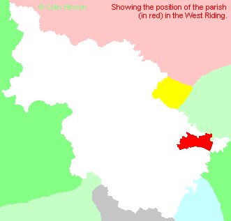
- For a detailed map of this parish see this parish boundaries map.
- For a more detailed map of the parishes in the riding please see the Yorkshire parish maps page.
- For a more detailed map of the county please see the Yorkshire map page.
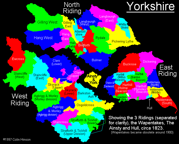
- Here is a map showing the wapentakes for the county.
You can see maps centred on OS grid reference SE641221 (Lat/Lon: 53.691423, -1.03077), Snaith which are provided by:
- OpenStreetMap
- Google Maps
- StreetMap (Current Ordnance Survey maps)
- Bing (was Multimap)
- Old Maps Online
- National Library of Scotland (Old Ordnance Survey maps)
- Vision of Britain (Click "Historical units & statistics" for administrative areas.)
- English Jurisdictions in 1851 (Unfortunately the LDS have removed the facility to enable us to specify a starting location, you will need to search yourself on their map.)
- Magic (Geographic information) (Click + on map if it doesn't show)
- GeoHack (Links to on-line maps and location specific services.)
- All places within the same township/parish shown on an Openstreetmap map.
- Nearby townships/parishes shown on an Openstreetmap map.
- Nearby places shown on an Openstreetmap map.
- The Roll of Honour in the Priory Church, Snaith.
- The War Memorial Plaque in the Priory Church, Snaith.
- The 1914-18, 1939-45 and 1981 War Memorial in East Cowick Churchyard.
- The 1914-18 and 1939-1945 War Memorial Rawcliffe.
- The 1914-1918 and 1939-45 War Memorial at Goole.
- The following places are within the boundaries of this (ancient) parish, but I have no further information on them other than the Ordnance Survey Landranger Grid reference shown:
- (SE747223) Old Goole
- This parish is covered by the following Society:
- A list of those paying the 1379 Subsidy Rolls (Poll Tax) for this parish.