
Hide
New Machar
hide
Hide
hide
Hide
Hide
Hide
"Machar, New, par. and ry. sta., Aberdeenshire and detached part of Banffshire, 9002 ac., pop. 1505; the sta. is 11½ miles NW. of Aberdeen; at New Machar Inn, near the station, horse and cattle fairs are held."
Bartholomew's Gazetteer of the British Isles, 1887
Hide
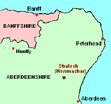
The parish of New Machar is nowadays reckoned as belonging to Aberdeenshire, and the main article about it will therefore be found among the GENUKI Aberdeenshire pages. However, before the major re-alignment of parish and county boundaries which came into effect on 1st May 1891, the parish belonged in part to Banffshire. The remaining articles on this page give details.
Hide
- Ask for a calculation of the distance from New Machar to another place.
Until 1st May 1891, the estate of Straloch belonged to Banffshire. On that date, it was transferred to Aberdeenshire, as part of a complicated exchange of territory, involving also the estate of Torryleith, which was transferred from the parish of Udny to the parish of New Machar. While there are archival consequences for the inhabitants of Torryleith, there are no genealogical implications for Straloch. OPRs, the civil Registers of Births, Deaths and Marriages, and the Census treat New Machar (including Straloch) as if it had always belonged exclusively to Aberdeenshire. And the Minister, writing for the "New Statistical Account" in 1842 states: " ... the lands of Straloch are now rated and politically attached to the County of Aberdeen".
You can see maps centred on OS grid reference NJ882184 (Lat/Lon: 57.256199, -2.197323), New Machar which are provided by:
- OpenStreetMap
- Google Maps
- StreetMap (Current Ordnance Survey maps)
- Bing (was Multimap)
- Old Maps Online
- National Library of Scotland (Old Ordnance Survey maps)
- Vision of Britain (Click "Historical units & statistics" for administrative areas.)
- Magic (Geographic information) (Click + on map if it doesn't show)
- GeoHack (Links to on-line maps and location specific services.)
- All places within the same township/parish shown on an Openstreetmap map.
- Nearby townships/parishes shown on an Openstreetmap map.
- Nearby places shown on an Openstreetmap map.