
Hide
Cheriton
hide
Hide
hide
Hide
hide
Hide
Hide
"A village in the north-west of the Gower peninsula. The church is Early English, and at Landimore are some remains of a fifteenth century castle.
On North Hill Tor is a Danish camp. [Glamorganshire, 1911]
Hide
Here is a substantial reading list of books which relate to Glamorgan, either county or parish.
The Glamorgan Family History Society have produced a set of microfiche containing Monumental Inscriptions for the following burial grounds :-
- Parish Church of St. Cadoc
Visit their website for information on how to purchase.
| St Cadog, Cheriton (Church in Wales) |
| St Cadog, Cheriton (Church in Wales) |
Glamorgan Chapels Database- None found in this parish.
For full and up-to-date details of their holdings see the sites of Glamorgan Record Office and/or West Glamorgan Archives
See Bap/Mar/Bur data on FreeReg
The church is dedicated to St. Cadoc, is in the Benefice of Llanrhidian with Llanmadoc and Cheriton, and the diocese of Swansea and Brecon. Details of the present incumbent of this benefice can be found at the Church in Wales website. The church can be located at grid reference SS450932.
| Anglican Parish Registers Held at the Glamorgan Record Office, Cardiff | ||||
| Baptisms | Marriages | Burials | Banns | Bishops Transcripts |
| 1672-1841 (transcript) | 1672-1841 (transcript) | 1672-1841 (transcript) | - | - |
There appear to be no non-conformist chapels in this parish but see Llanmadog for details of Trinity Calvinistic Methodist chapel which is on the parish border and is listed under Cheriton on some sources.
Transcript of complete name listing for the Gower parishes, from Slaters Directory for 1880.
The transcription of the section for Cheriton from The National Gazetteer (1868) provided by Colin Hinson.
Here are Descriptions of this parish extracted from two separate sources;
A Topographical Dictionary of The Dominion of Wales by Nicholas Carlisle, London, 1811.
A Topographical Dictionary of Wales by Samuel Lewis 1833
- Ask for a calculation of the distance from Cheriton to another place.
Description & Illustrations of Landimore (aka Bovehill) Castle at www. castlewales.com by Jeff Thomas
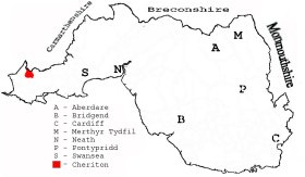
This diagram shows the position of this parish within the county of Glamorgan
|
Parish map (Kain/Oliver)
Plan of the parish of Cheriton in the County of Glamorgan - on the People's Collection Wales site
You can see maps centred on OS grid reference SS458929 (Lat/Lon: 51.613885, -4.228921), Cheriton which are provided by:
- OpenStreetMap
- Google Maps
- StreetMap (Current Ordnance Survey maps)
- OpenStreetMap Cymru (Welsh counties only)
- Bing (was Multimap)
- Old Maps Online
- National Library of Scotland (Old Ordnance Survey maps)
- Vision of Britain (Click "Historical units & statistics" for administrative areas.)
- Magic (Geographic information) (Click + on map if it doesn't show)
- GeoHack (Links to on-line maps and location specific services.)
- All places within the same township/parish shown on an Openstreetmap map.
- Nearby townships/parishes shown on an Openstreetmap map.
- Nearby places shown on an Openstreetmap map.
Places, villages, farms etc within Cheriton parish as shown on the online parish map from the CD of Historic Parishes of England and Wales: an Electronic Map of Boundaries before 1850 with a Gazetteer and Metadata [computer file]. (Kain, R.J.P., Oliver, R.R.). (Extracted by Mary Greatorex)
- Cheriton (31): Bury Pill, Bovehill, castle (remains of ) Cheriton, Great Pill, Landimore, Landimore Marsh, North Hills, North Hill Tor, Ryers Down, The Bulwark, Weobley Castle.
The Population of Cheriton was as follows, and a more detailed breakdown is available.
| 1841 - 282 | 1851 - 312 | 1861 - 230 | 1871 - 153 | 1881 - 173 | 1891 - 155 |
Details of extant records on Archives Network Wales for the following;
- Cheriton Parish Council records 1848-[late 20th century]
Details of extant records on Archives Network Wales for the following;
- Cheriton and Llanmadoc School log books 1904-1935 "....... established as a National School but closed in 1935"