
Hide
Hemswell
hide
Hide
hide
Hide
hide
Hide
Hide
Hide
The Gainsborough Library is an excellent resource with both a Local History section and a Family History section.
Alternatively, the Libraries at Scunthorpe also have a Local History section.
- The Hemswell Cemetery is situated on Hemswell Lane.
- The Cemetery is managed by the Hemswell Parish Council.
- Julian P. GUFFOGG has photograph of the Churchyard on Geo-graph, taken in May, 2015.
- Ian S. has a photograph of the Lychgate into All Saints churchyard on Geo-graph, taken in May, 2018.
- The parish was in the Scotter sub-district of the Gainsborough Registration District.
- The North Lincolnshire Library holds a copy of the parish census returns for 1841 through 1901.
- Check our Census Resource page for county-wide resources.
- The table below gives census piece numbers, where known:
| Census Year | Piece No. |
|---|---|
| 1841 | H.O. 107 / 637 |
| 1851 | H.O. 107 / 2119 |
| 1861 | R.G. 9 / 2405 |
| 1871 | R.G. 10 / 3442 |
| 1891 | R.G. 12 / 2632 |
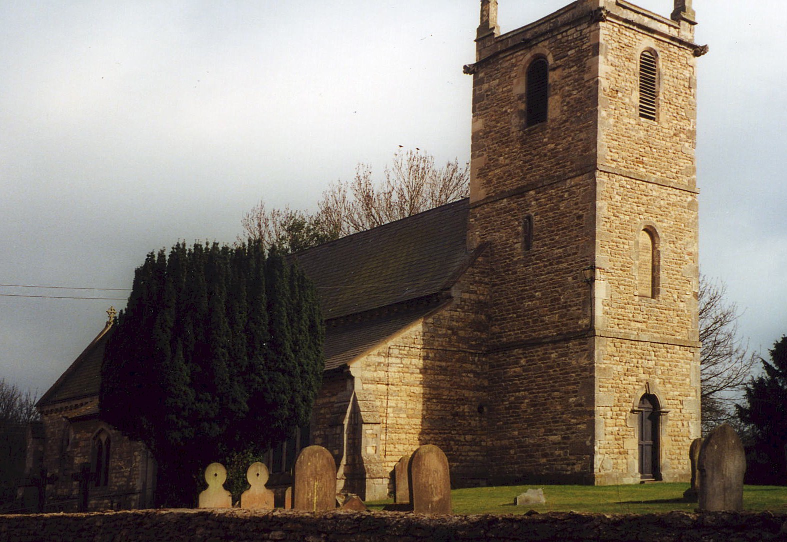
- The Anglican parish church is dedicated to All Saints.
- The church dates back to the 13th century.
- The church was partially rebuilt when a new tower was added in 1764.
- The church was restored in 1858.
- The church seats about 220.
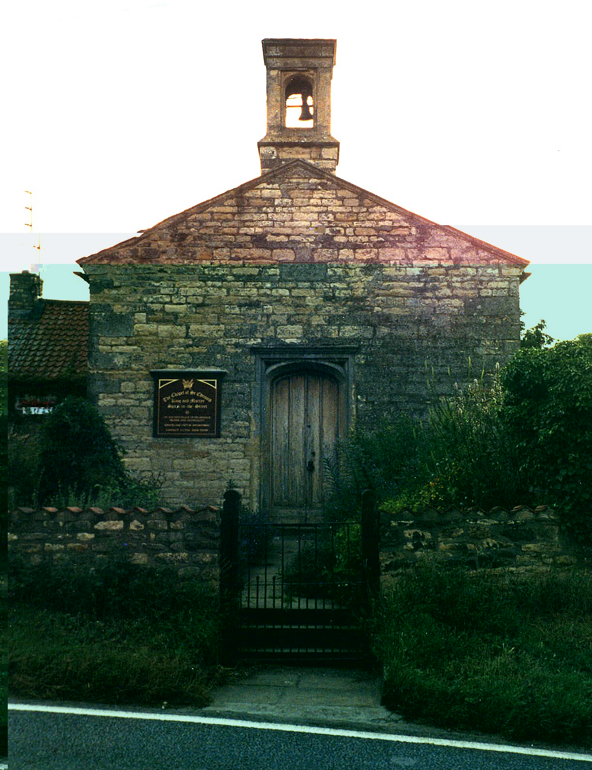
- St. Edmund's chapel of ease, associated with All Saints, was established at Spital (see History). The original building was replaced in 1664. It was restored in 1890 and seats about 50 persons.
- There is a photograph of All Saints Church on the Wendy PARKINSON web site.
- Richard CROFT has a photograph of All Saints' Cchurch on geo-graph, taken in January, 2006.
- Julian GUFFOGG has a photograph of the Church interior on geo-graph, taken in May, 2015.
- Here is a photo of All Saints Church, taken by Ron COLE (who retains the copyright):
- Here is a photo of St. Edmund's chapel of ease, taken by Ron COLE (who retains the copyright):
- Parish registers exist from 1676, but the Bishop's transcripts go back to 1599.
- The North Lincolnshire Library holds a copy of the parish register entries for baptisms 1685-1885, burials 1684-1963 and marriages 1685-1836.
- We have a handful of entries extracted from the Helmswell parish register. Your additions are welcome.
- The stone font bears the arms of the MONSON family.
- The Lincolnshire FHS has published several marriage and burial indexes for the Corringham Deanery to make your search easier.
- The Wesleyan Methodists had a chapel here, as did the Primitive Methodists. The Wesleyans also established a school to educate 12 poor children of the parish. For more on these chapels and their records, check our Non-Conformist Church Records page for additional resources.
- Check our Church Records page for county-wide resources.
- The parish was in the Scotter sub-district of the Gainsborough Registration District.
- Check our Civil Registration page for sources and background on Civil Registration which began in July, 1837.
Hemswell is both a parish and a village lying in a valley about 8 miles east of Gainsborough and 9 miles north of Lincoln. The parish itself is bordered on the north by Willoughton parish, to the west by Corringham parish and to the south by Harpwell parish. The parish covers about 2,660 acres.
Hemswell village sits just off the main roads. The small hamlet of Spital (or Spital-in-the-Street) is 3 miles south-east and has its western part within Hemswell parish. Spital is divided by the A15 and A631 trunk roads. If you are planning a visit:
- Hemswell has a chalybeate spring on the north-east side of the village, which gave its name to the whole parish.
- The village can be accessed off of the A631 trunk road east of Gainsborough. Turn north at the B1398 and go almost a mile and the village will be on your left.
- J. THOMAS has a photograph of the Village Hall on Geo-graph, taken in 2012. You should stop in and get a schedule of forth-coming events.
- If you are approaching from the west, keep an eye open for this Bench and village sign as photographed by Steve FAREHAM on Geo-graph, taken in September, 2015. The cemetery will be just to your right.
- Visit our touring page for more sources.
- Ask for a calculation of the distance from Hemswell to another place.
- The ancient Roman Road from Lincoln City to the Humber, Ermine Street, forms the eastern boundary of the parish and runs through the hamlet of Spital.
- A statue fair or hiring fair was held at Spital on each May Day.
- The Hospital, for which Spital is named, apparently had an ancient past, dating back to Edward II. A license was granted to John, son of Richard de VENDEUR, vicar of Thevelby, to endow John with land in Hemswell and Harpswell for the Hospital. But other sources say the hospital existed prior to the granting of the license, serving pilgrims and wayfarers. In 1396, Thomas de Aston made considerable additions to the hospital. The buildings decayed and the property passed through several hands, the funds were misappropriated and eventually the hospital was reduced to a chapel of ease. The chapel stands at the northern edge of the site formerly occupied by the hospital.
- Opposite the churchyard is a 19th-century maypole of wood and wrought iron with painted red white and blue stripes. It is one of the oldest in England, and danced 'round each May Day during the village May Day Fete.
- Jonathan BILLINGER has a photograph of the Maypole on Geo-graph, taken in January, 2007.
- Richard CROFT also has a photograph of the Maypole on Geo-graph, taken in January, 2006.
- In 1841, the chief landowners in the parish were Sir Thomas WHICHCOTE and the Mayor and Corporation of Lincoln.
- In 1872, 1900 and 1913, the chief landowners in the parish were Sir George WHICHCOTE, baronet, and the Mayor and Corporation of Lincoln.
- See our Maps page for additional resources.
You can see maps centred on OS grid reference SK931909 (Lat/Lon: 53.406715, -0.601004), Hemswell which are provided by:
- OpenStreetMap
- Google Maps
- StreetMap (Current Ordnance Survey maps)
- Bing (was Multimap)
- Old Maps Online
- National Library of Scotland (Old Ordnance Survey maps)
- Vision of Britain (Click "Historical units & statistics" for administrative areas.)
- English Jurisdictions in 1851 (Unfortunately the LDS have removed the facility to enable us to specify a starting location, you will need to search yourself on their map.)
- Magic (Geographic information) (Click + on map if it doesn't show)
- GeoHack (Links to on-line maps and location specific services.)
- All places within the same township/parish shown on an Openstreetmap map.
- Nearby townships/parishes shown on an Openstreetmap map.
- Nearby places shown on an Openstreetmap map.
- The Royal Flying Corps (RFC) opened an airfield here in World War One in late 1916. It was a night landing field and was called "RAF Harpswell".
- The field was closed in 1919 and returned to pasture.
- The RAF seized the land in 1935 and opened RAF Hemswell in January, 1937.
- Three different Polish squadrons flew from this airfield during WWII.
- The field closed for repaving in June, 1943. It re-opened in January, 1944.
- During World War II, 122 bomber aircraft from Hemswell were lost in combat operations.
- The last aircraft left Hemswell in 1956 and the base was converted to a Thor Missile unit.
- The airfield closed in 1967.
- Much of the facility has been retained. You can see Photographs of buildings and museum aircraft.
- An outdoor display of the RAF in Lincolnshire was moved to Hemswell some years ago. The display is only open on Sundays.
The war memorial reads:
TO THE GLORY OF GOD AND IN HONOURED MEMORY OF THE MEN OF THIS PARISH WHO LAID DOWN THEIR LIVES IN THE GREAT WAR 1914-1918
- John BELL
- James BIRKETT
- Arthur HOLMES
- Norman A LINSEY
- Harry MIDDLETON
- Bertie OGLESBY
- George PARISH
- William A PARISH
- Ernest REDHEAD
- Albert SHEPHERD
There is a separate brass plaque to James BIRKITT (spelling is different than shown) as above. Plaque is topped by an engraving of the Lincoln Regiment "Sphinx" cap badge, with the word EGYPT inscribed beneath. In Loving memory of Arthur James Birkitt of the 3rd Lincolns Regt. the much loved son of J and A Birkitt who was killed in action in France 12th April 1917 in his 24th year.
"He gave his life for his Country" - From one who held him in the greatest esteem.
A Second World War Memorial has the R.A.F Crest and motto "Per Ardua Ad Astra", and reads:
IN PROUD AND HONOURED MEMORY OF DOUGLAS JAMES POPPLE, FLIGHT SERGEANT R.A.F. WHO GAVE HIS LIFE ON ACTIVE SERVICE 24th JULY 1942 AGED 22 YEARS.
They died that we might live. Erected by his fellow parishioners.
Only Ernest REDHEAD is buried in the local churchyard. He was a private in the 10th Btn., Sherwood Foresters and died on 5 June 1917 at age 23, son of Henry and Eliza REDHEAD, of Glenthworth, LIN.
- The name Hemswell comes from the Old English Helm+wella for "spring or stream of a man called Helm". The name appears in the 1086 Domesday Book as Helmeswella. The name is recorded in some records as Elmswell.
A. D. MILLS, "A Dictionary of English Place-Names," Oxford University Press, 1991.
- White's 1841 Directory lists the following names in the parish: BAINBOROUGH, BARR, BEAUMONT, BRUMBY, COUPLAND, DEWICK, HALL, HILL, HOLMES, KEYWORTH, LEIGHTON, MARSHALL, MARTIN, ROBINSON, RUSTON, SMITH, STORR, TAYLOR, THOMAS, TREVER, TURNER, TUXFORD and WINN.
- White's 1872 Directory lists the following surnames in the parish: ATKINSON, BAINBRIDGE, BARRATT, BEAUMONT, BRUMBY, CLIXBY, COOK, COUPLAND, HOLMES, KIRKBY, KITCHEN, LAMBETH, LOVE, MARSHALL, MILLS, OGLESBY, SMITH, TUXFORD, VICKERS, WALKER and WASS.
- Kelly's 1900 Directory lists the following names in the parish: Elizabeth BEAUMONT, Coggon BRUMBY, Mrs. CARTER, Thomas COOK, George COULSON, George COUPLAND, George CRUST, Charles H. HARS, Frank A. HOLMES, Eunice HORTON, Thomas LARRATT, Charles LOVE, Rev. Timothy G. LYNDE, ("brothers") MILLER, Alfred and John OGLESBY, John RUSTON, Miss SMITH, Mary SMITH, Harry G. THORPE, Wm. WALKER, Rev. Ernest W. VAUGHN and William WRAY.
- Kelly's 1913 Directory lists the following names in the parish: Elizabeth BEAUMONT, Coggon BRUMBY, Rev. Robert P. CARROLL, Mrs. CARTER, Charles COBB, George CRUST, Terah ELWOOD, Frank A. HOLMES, Rachel HORTON, Charles LOVE, Cedric H. MARSHALL, Fred and Harry MILLER, Alfred and John OGLESBY, Henry REDHEAD, John TATUM, Harvey G. THORPE and William WRAY.
- In 1908, who had the largest family?
- This place was an ancient parish in Lincoln county and became a modern Civil Parish when those were established.
- The parish was in the ancient Aslacoe Wapentake in the West Lindsey district in the parts of Lindsey.
- The southern part of the parish was in the Corringham Wapentake.
- You may contact the local Hemswell Parish Council regarding civic or political issues, but they are NOT staffed to help with family history lookups.
- Today's district governance is provided by the West Lindsey District Council.
- Bastardy cases would be heard in the Gainsborough petty session hearings.
- The poor had the income of 20 shillings per year (1872) distributed to them from a charity left by Thomas CODD of Snarford in 1662.
- After the 1834 Poor Law Amendment Act reforms, the parish became part of the Gainsborough Poorlaw Union.
- There is a photograph of the Spital's almhouses at the Images of England website. This is a Grade II listed building with British Heritage.
- The Public Elementary School was erected in 1859 by Sir Thomas WHICHCOTE, baronet, and enlarged in 1879 to hold 100 children.
- Ian S. has a photograph of the former school at Hemswell on Geo-graph, taken in May, 2018.
- For more on researching school records, see our Schools Research page.