
Hide
Rathven
hide
Hide
hide
Hide
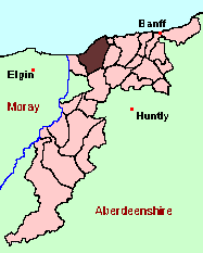
See the Maps Section below for links to
a fully-detailed version of this location plan.
Hide
Hide
" The parish is situated in the district of the country named Enzie. It extends along the coast, from east to west, 10 miles, and nearly 5 in breadth; and is bounded on the north, by the Moray Frith; on the east and south-east, by the parishes of Cullen and Deskford; on the south, by Deskford and Keith; and on the west, by Bellie. It contains 27.000 Scotch acres, or 33, 750 imperial, and 45 and one-fifth square miles. . . There is an extensive range of hills stretching from the Benhill on the south-east, which bounds the southern part of the parish westwards. The Benhill, the highest, is 945 feet above the level of the sea, and serves as a land-mark to the fishermen, being seen by them, according to their calculations, at fully fifteen leagues distance." [Contributed in march, 1842, by the Rev. James Gardner, Minister of Rathven, to The New Statistical Account of Scotland, Vol. XIII.]
Hide
There are no published Monumental Inscriptions for Rathven. Aberdeen And North-East Scotland FHS (ANESFHS) hold some unpublished MIs for the parish. Members may request lookups.
These are included in the Online Index to the MIs
Aberdeen And North-East Scotland FHS (ANESFHS) have published a name Index to the 1851 Census for Banffshire. Rathven is published as code AA215.ANESFHS also hold unpublished indexes and transcriptions of the 1861 Census for most Banffshire parishes (including Rathven).
| Buckie, Church of Scotland |
| Rathven, Church of Scotland |
Kirk of Scotland
- OPRs held by the General Register Office, Scotland.
GROS Baptism Marriage Death 164/1 1716-1819 - - 164/2 - 1710-1819 1724-90 164/3 1820-54 1820-54 - - LDS Film numbers:
Baptisms Marriages Deaths 6902585(2) 6902586(2) 991192 - Batch numbers (for FamilySearch)
Baptisms (C) Marriages (M) C111642
C111643
C111644M111642
M111644Note that because of the annexations described under Historical Geography, it may be worth looking under the parishes of Cullen and Enzie.
Catholic Church
The following registers of St Peter's, Buckie are held at the National Archives of Scotland with the catalogue numbers shown:
- B:1818 -1860 (RH MP8/1)
- B: 1844 -1895 (RH21/16)
Other Catholic records are listed under the parish of Enzie, which overlapped with Rathven.
Kirk Session Records
Kirk Session records generally include records of Discipline, which often include information on illegitimate births, and Accounts, which may mention persons on Poor Relief. The surviving Rathven Kirk Session records are listed on a separate webpage.
Rathven in1842 (from the New Statistical Account)
- Ask for a calculation of the distance from Rathven to another place.
Most of the coastal and lowland parishes of Banffshire are fairly small in extent, and could (until well on in the 19th century) be adequately served by a single parish church. Rathven, on the other hand, seems always to have been a bit too big, both in area and in population, and as a result, has from quite early on had bits of itself "nibbled away".
The first such loss was at the eastern end of the parish, where the village of Portknockie and some of the surrounding countryside were effectively annexed quoad sacra (= "for church purposes") by the parish of Cullen. The genealogical implications of this are described in the article on Cullen quoad sacra.
The other major loss was at the western end of the parish. A "chapel of ease" (that is, a church under the governance of the Minister and Kirk Session of the parish) was established at Enzie in 1785. The considerable genealogical ramifications of this are described in the article on Enzie
There is a wide range of maps available for Rathven, historical and modern, on paper and online. Many ancient placenames continue in use, and will therefore appear on modern maps, but as parishes ceased to be of any significance for Local Government in Scotland in 1974, parish boundaries will be found only on historical maps.
Maps on Paper
- The best general-purpose modern printed map is the Ordnance Survey "Landranger" Series, which has a scale of 1:50000 (about one-and-a-quarter inches to a mile). Rathven will be found on "Landranger" sheets 28 & 29.
- Reproductions of late-19th century Ordnance Survey maps are published by Caledonian Maps, and are also available via Family History Societies. Rathven will be found on sheets 95 and 96.
Maps Online
- The small location plan at the head of this page is based on an 1845 map included in the Banffshire volume of the New Statistical Account of Scotland. View a fully-detailed version of this map.
You can see maps centred on OS grid reference NJ443657 (Lat/Lon: 57.677694, -2.9356), Rathven which are provided by:
- OpenStreetMap
- Google Maps
- StreetMap (Current Ordnance Survey maps)
- Bing (was Multimap)
- Old Maps Online
- National Library of Scotland (Old Ordnance Survey maps)
- Vision of Britain (Click "Historical units & statistics" for administrative areas.)
- Magic (Geographic information) (Click + on map if it doesn't show)
- GeoHack (Links to on-line maps and location specific services.)
- All places within the same township/parish shown on an Openstreetmap map.
- Nearby townships/parishes shown on an Openstreetmap map.
- Nearby places shown on an Openstreetmap map.
You can view a comprehensive Gazetteer list for Rathven including placenames culled from the Ordnance Survey "Explorer" (1:25000) map, the Ordnance Survey "Landranger" [1:50000], the 1896 Ordnance Survey 1" map, the 1841, 1851, 1861 and 1881 Census and Thomson's "Atlas of Scotland" (1832).
You can also view the equivalent lists for Enzie and Cullen 'quoad sacra' as described above under "Historical Geography".
Under the "Poor Law Amendment Act, Scotland" (1845) responsibility for Poor Relief was taken from the Parishes of the Kirk of Scotland, and vested in new Parochial Boards, whose territories largely coincided with the old parishes. The Parochial Boards were not (as in England) grouped into Poor Law Unions, and there were few Poorhouses outside the cities and large towns.
Day-to-day administration of the Poor Law was in the hands of the Inspector of the Poor for each parish, and these Inspectors were obliged by law to maintain detailed records of applications and of relief supplied. The most valuable of these are the "Record of Applications" and the "General Register of the Poor". The "Minutes" are very variable, but on occasion can also contain information on named individuals.
The following Poor Law records have survived for the Parish of Rathven:
- Minutes
Note, however, that surviving Poor Law records for Bellie, Moray, include some claimants from the quoad sacra parish of Enzie, which was hived off from Rathven in 1835.
These are held by Aberdeen City Archives. The records are available for viewing, subject to the 100-year rule.
Items marked * are included in a name index compiled by Aberdeen And North-East Scotland FHS (ANESFHS), and held by both ANESFHS and Aberdeen City Archives.
- according to New Statistical Account:
Year 1720 1755 1793 1801 1811 1821 1831 1841 Population 2300 2898 3019* 3901 4374 5364 6484 6826 *"In 1793, exclusive of that part of the east end of the parish annexed to Cullen quoad sacra, the population was 3019, of whom 1408 were males, 1411 females; 1766 Presbyterians, 303 Episcopalians, 950 Catholics; and 720 familes."- according to Ordnance Gazetteer of Scotland (1895):
Year 1801 1831 1861 1871 1881 1891 Population 3901 6484 8240 10,199 11,180 12,925
You can also see Family History Societies covering the nearby area, plotted on a map. This facility is being developed, and is awaiting societies to enter information about the places they cover.